You are here: Home > Network List > EI - Irish National Seismic Network (INSN) Stations List
> Station ILTH Corrakit Louth > Earthquake Result Viewer
ILTH Corrakit Louth - Earthquake Result Viewer
| Earthquake location: |
Near Coast Of Ecuador |
| Earthquake latitude/longitude: |
0.4/-79.9 |
| Earthquake time(UTC): |
2016/04/16 (107) 23:58:37 GMT |
| Earthquake Depth: |
19 km |
| Earthquake Magnitude: |
7.8 MWW, 7.4 MI |
| Earthquake Catalog/Contributor: |
NEIC PDE/NEIC COMCAT |
|
| Network: |
EI Irish National Seismic Network (INSN) |
| Station: |
ILTH Corrakit Louth |
| Lat/Lon: |
54.06 N/6.27 W |
| Elevation: |
227 m |
|
| Distance: |
80.2 deg |
| Az: |
35.048 deg |
| Baz: |
256.905 deg |
| Ray Param: |
0.04845113 |
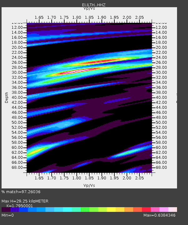
| Estimated Moho Depth: |
29.25 km |
| Estimated Crust Vp/Vs: |
1.80 |
| Assumed Crust Vp: |
6.276 km/s |
| Estimated Crust Vs: |
3.496 km/s |
| Estimated Crust Poisson's Ratio: |
0.27 |
|
| Radial Match: |
97.26036 % |
| Radial Bump: |
320 |
| Transverse Match: |
84.73478 % |
| Transverse Bump: |
400 |
| SOD ConfigId: |
7422571 |
| Insert Time: |
2019-04-22 08:01:02.055 +0000 |
| GWidth: |
2.5 |
| Max Bumps: |
400 |
| Tol: |
0.001 |
|

Signal To Noise
| Channel | StoN | STA | LTA |
| EI:ILTH: :HHZ:20160417T00:10:14.139985Z | 31.957605 | 1.4219857E-5 | 4.4496002E-7 |
| EI:ILTH: :HHN:20160417T00:10:14.139985Z | 3.568824 | 1.1830306E-6 | 3.314903E-7 |
| EI:ILTH: :HHE:20160417T00:10:14.139985Z | 18.669903 | 4.83847E-6 | 2.591588E-7 |
| Arrivals |
| Ps | 3.8 SECOND |
| PpPs | 13 SECOND |
| PsPs/PpSs | 16 SECOND |


