You are here: Home > Network List > GB - Great Britain Seismograph Network Stations List
> Station INVG INVERGELDIE , ENGLAND > Earthquake Result Viewer
INVG INVERGELDIE , ENGLAND - Earthquake Result Viewer
| Earthquake location: |
Near Coast Of Ecuador |
| Earthquake latitude/longitude: |
0.4/-79.9 |
| Earthquake time(UTC): |
2016/04/16 (107) 23:58:37 GMT |
| Earthquake Depth: |
19 km |
| Earthquake Magnitude: |
7.8 MWW, 7.4 MI |
| Earthquake Catalog/Contributor: |
NEIC PDE/NEIC COMCAT |
|
| Network: |
GB Great Britain Seismograph Network |
| Station: |
INVG INVERGELDIE , ENGLAND |
| Lat/Lon: |
56.43 N/4.04 W |
| Elevation: |
279 m |
|
| Distance: |
81.9 deg |
| Az: |
32.973 deg |
| Baz: |
258.403 deg |
| Ray Param: |
0.0472386 |
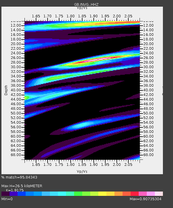
| Estimated Moho Depth: |
26.5 km |
| Estimated Crust Vp/Vs: |
1.92 |
| Assumed Crust Vp: |
6.276 km/s |
| Estimated Crust Vs: |
3.273 km/s |
| Estimated Crust Poisson's Ratio: |
0.31 |
|
| Radial Match: |
95.84343 % |
| Radial Bump: |
345 |
| Transverse Match: |
87.19989 % |
| Transverse Bump: |
400 |
| SOD ConfigId: |
7422571 |
| Insert Time: |
2019-04-22 08:01:22.556 +0000 |
| GWidth: |
2.5 |
| Max Bumps: |
400 |
| Tol: |
0.001 |
|

Signal To Noise
| Channel | StoN | STA | LTA |
| GB:INVG: :HHZ:20160417T00:10:23.439973Z | 19.641289 | 1.1161668E-5 | 5.6827577E-7 |
| GB:INVG: :HHN:20160417T00:10:23.439973Z | 2.9551992 | 1.1721057E-6 | 3.9662496E-7 |
| GB:INVG: :HHE:20160417T00:10:23.439973Z | 10.184886 | 3.724417E-6 | 3.6568076E-7 |
| Arrivals |
| Ps | 4.0 SECOND |
| PpPs | 12 SECOND |
| PsPs/PpSs | 16 SECOND |


