You are here: Home > Network List > GB - Great Britain Seismograph Network Stations List
> Station LRW LERWICK, SHETLAND ISLANDS > Earthquake Result Viewer
LRW LERWICK, SHETLAND ISLANDS - Earthquake Result Viewer
| Earthquake location: |
Near Coast Of Ecuador |
| Earthquake latitude/longitude: |
0.4/-79.9 |
| Earthquake time(UTC): |
2016/04/16 (107) 23:58:37 GMT |
| Earthquake Depth: |
19 km |
| Earthquake Magnitude: |
7.8 MWW, 7.4 MI |
| Earthquake Catalog/Contributor: |
NEIC PDE/NEIC COMCAT |
|
| Network: |
GB Great Britain Seismograph Network |
| Station: |
LRW LERWICK, SHETLAND ISLANDS |
| Lat/Lon: |
60.14 N/1.18 W |
| Elevation: |
98 m |
|
| Distance: |
84.1 deg |
| Az: |
29.571 deg |
| Baz: |
260.422 deg |
| Ray Param: |
0.04571602 |
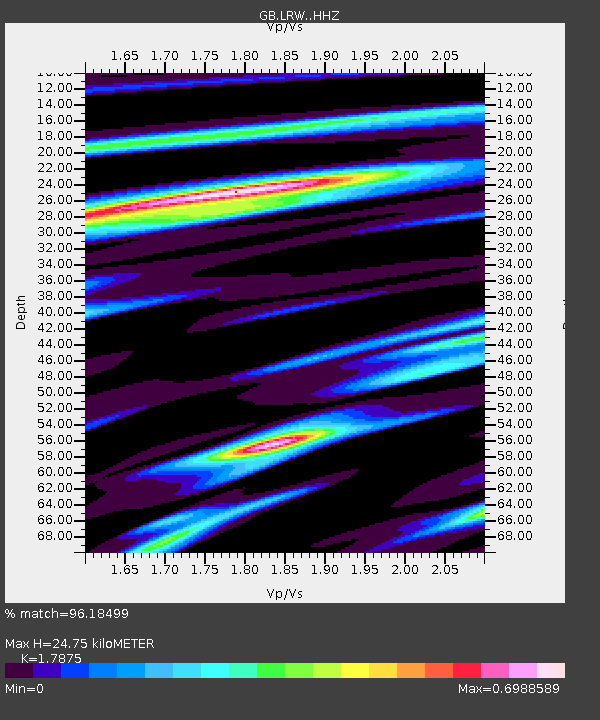
| Estimated Moho Depth: |
24.75 km |
| Estimated Crust Vp/Vs: |
1.79 |
| Assumed Crust Vp: |
6.134 km/s |
| Estimated Crust Vs: |
3.432 km/s |
| Estimated Crust Poisson's Ratio: |
0.27 |
|
| Radial Match: |
96.18499 % |
| Radial Bump: |
400 |
| Transverse Match: |
79.71886 % |
| Transverse Bump: |
400 |
| SOD ConfigId: |
7422571 |
| Insert Time: |
2019-04-22 08:01:27.121 +0000 |
| GWidth: |
2.5 |
| Max Bumps: |
400 |
| Tol: |
0.001 |
|

Signal To Noise
| Channel | StoN | STA | LTA |
| GB:LRW: :HHZ:20160417T00:10:34.639985Z | 20.233082 | 1.0579779E-5 | 5.2289505E-7 |
| GB:LRW: :HHN:20160417T00:10:34.639985Z | 1.1071364 | 7.6800745E-7 | 6.9368826E-7 |
| GB:LRW: :HHE:20160417T00:10:34.639985Z | 5.9651985 | 3.92961E-6 | 6.58756E-7 |
| Arrivals |
| Ps | 3.3 SECOND |
| PpPs | 11 SECOND |
| PsPs/PpSs | 14 SECOND |


