You are here: Home > Network List > IM - International Miscellaneous Stations Stations List
> Station TKL Tuckaleechee Caverns, TN, USA > Earthquake Result Viewer
TKL Tuckaleechee Caverns, TN, USA - Earthquake Result Viewer
| Earthquake location: |
Near Coast Of Ecuador |
| Earthquake latitude/longitude: |
0.4/-79.9 |
| Earthquake time(UTC): |
2016/04/16 (107) 23:58:37 GMT |
| Earthquake Depth: |
19 km |
| Earthquake Magnitude: |
7.8 MWW, 7.4 MI |
| Earthquake Catalog/Contributor: |
NEIC PDE/NEIC COMCAT |
|
| Network: |
IM International Miscellaneous Stations |
| Station: |
TKL Tuckaleechee Caverns, TN, USA |
| Lat/Lon: |
35.66 N/83.77 W |
| Elevation: |
351 m |
|
| Distance: |
35.3 deg |
| Az: |
354.591 deg |
| Baz: |
173.353 deg |
| Ray Param: |
0.077280596 |
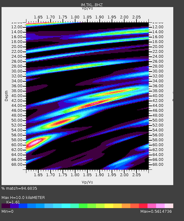
| Estimated Moho Depth: |
10.0 km |
| Estimated Crust Vp/Vs: |
1.61 |
| Assumed Crust Vp: |
6.35 km/s |
| Estimated Crust Vs: |
3.944 km/s |
| Estimated Crust Poisson's Ratio: |
0.19 |
|
| Radial Match: |
94.6835 % |
| Radial Bump: |
349 |
| Transverse Match: |
81.99314 % |
| Transverse Bump: |
400 |
| SOD ConfigId: |
7422571 |
| Insert Time: |
2019-04-22 08:02:09.322 +0000 |
| GWidth: |
2.5 |
| Max Bumps: |
400 |
| Tol: |
0.001 |
|

Signal To Noise
| Channel | StoN | STA | LTA |
| IM:TKL: :BHZ:20160417T00:04:59.618989Z | 34.60969 | 9.0632875E-6 | 2.6187135E-7 |
| IM:TKL: :BHN:20160417T00:04:59.618989Z | 31.753353 | 5.5053047E-6 | 1.7337712E-7 |
| IM:TKL: :BHE:20160417T00:04:59.618989Z | 2.8395174 | 4.4098496E-7 | 1.553028E-7 |
| Arrivals |
| Ps | 1.0 SECOND |
| PpPs | 3.8 SECOND |
| PsPs/PpSs | 4.8 SECOND |


