You are here: Home > Network List > IM - International Miscellaneous Stations Stations List
> Station TX32 Lajitas Array Site 32 (same as tx01 and TX00) > Earthquake Result Viewer
TX32 Lajitas Array Site 32 (same as tx01 and TX00) - Earthquake Result Viewer
| Earthquake location: |
Near Coast Of Ecuador |
| Earthquake latitude/longitude: |
0.4/-79.9 |
| Earthquake time(UTC): |
2016/04/16 (107) 23:58:37 GMT |
| Earthquake Depth: |
19 km |
| Earthquake Magnitude: |
7.8 MWW, 7.4 MI |
| Earthquake Catalog/Contributor: |
NEIC PDE/NEIC COMCAT |
|
| Network: |
IM International Miscellaneous Stations |
| Station: |
TX32 Lajitas Array Site 32 (same as tx01 and TX00) |
| Lat/Lon: |
29.33 N/103.67 W |
| Elevation: |
996 m |
|
| Distance: |
36.6 deg |
| Az: |
323.923 deg |
| Baz: |
137.593 deg |
| Ray Param: |
0.07655269 |
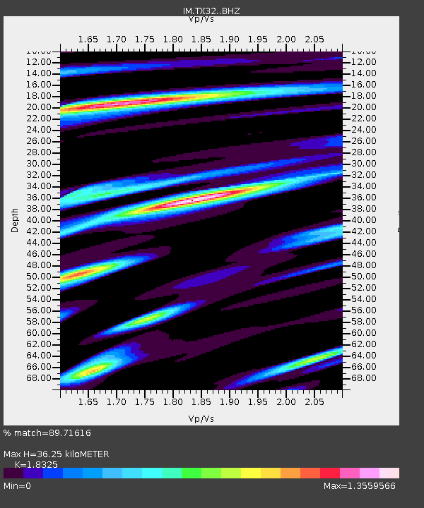
| Estimated Moho Depth: |
36.25 km |
| Estimated Crust Vp/Vs: |
1.83 |
| Assumed Crust Vp: |
6.419 km/s |
| Estimated Crust Vs: |
3.503 km/s |
| Estimated Crust Poisson's Ratio: |
0.29 |
|
| Radial Match: |
89.71616 % |
| Radial Bump: |
400 |
| Transverse Match: |
70.80452 % |
| Transverse Bump: |
400 |
| SOD ConfigId: |
7422571 |
| Insert Time: |
2019-04-22 08:02:10.293 +0000 |
| GWidth: |
2.5 |
| Max Bumps: |
400 |
| Tol: |
0.001 |
|

Signal To Noise
| Channel | StoN | STA | LTA |
| IM:TX32: :BHZ:20160417T00:05:11.174989Z | 6.264483 | 1.046185E-6 | 1.6700263E-7 |
| IM:TX32: :BHN:20160417T00:05:11.174989Z | 3.8332975 | 5.776075E-7 | 1.5068164E-7 |
| IM:TX32: :BHE:20160417T00:05:11.174989Z | 2.077323 | 4.8941683E-7 | 2.3559977E-7 |
| Arrivals |
| Ps | 5.1 SECOND |
| PpPs | 15 SECOND |
| PsPs/PpSs | 20 SECOND |


