You are here: Home > Network List > LD - Lamont-Doherty Cooperative Seismographic Network Stations List
> Station LUPA Lehigh University, PA > Earthquake Result Viewer
LUPA Lehigh University, PA - Earthquake Result Viewer
| Earthquake location: |
Near Coast Of Ecuador |
| Earthquake latitude/longitude: |
0.4/-79.9 |
| Earthquake time(UTC): |
2016/04/16 (107) 23:58:37 GMT |
| Earthquake Depth: |
19 km |
| Earthquake Magnitude: |
7.8 MWW, 7.4 MI |
| Earthquake Catalog/Contributor: |
NEIC PDE/NEIC COMCAT |
|
| Network: |
LD Lamont-Doherty Cooperative Seismographic Network |
| Station: |
LUPA Lehigh University, PA |
| Lat/Lon: |
40.60 N/75.37 W |
| Elevation: |
236 m |
|
| Distance: |
40.3 deg |
| Az: |
5.385 deg |
| Baz: |
187.08 deg |
| Ray Param: |
0.07447974 |
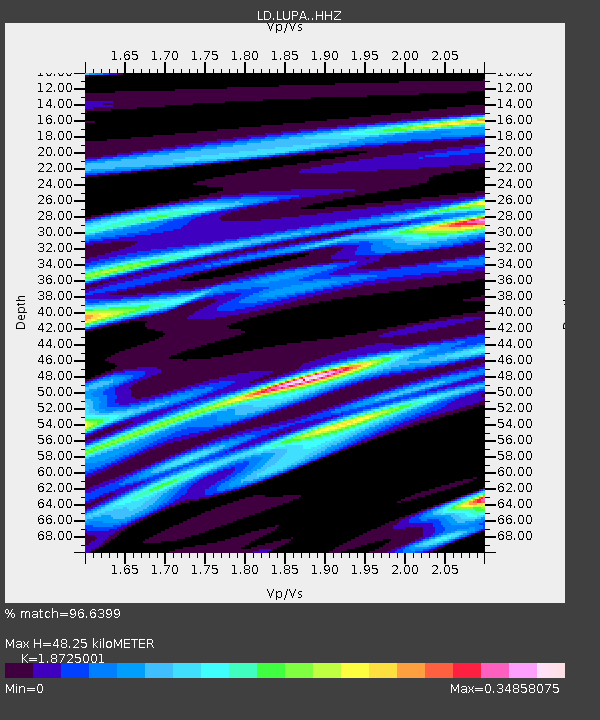
| Estimated Moho Depth: |
48.25 km |
| Estimated Crust Vp/Vs: |
1.87 |
| Assumed Crust Vp: |
6.283 km/s |
| Estimated Crust Vs: |
3.356 km/s |
| Estimated Crust Poisson's Ratio: |
0.30 |
|
| Radial Match: |
96.6399 % |
| Radial Bump: |
185 |
| Transverse Match: |
79.177444 % |
| Transverse Bump: |
400 |
| SOD ConfigId: |
7422571 |
| Insert Time: |
2019-04-22 08:02:33.013 +0000 |
| GWidth: |
2.5 |
| Max Bumps: |
400 |
| Tol: |
0.001 |
|
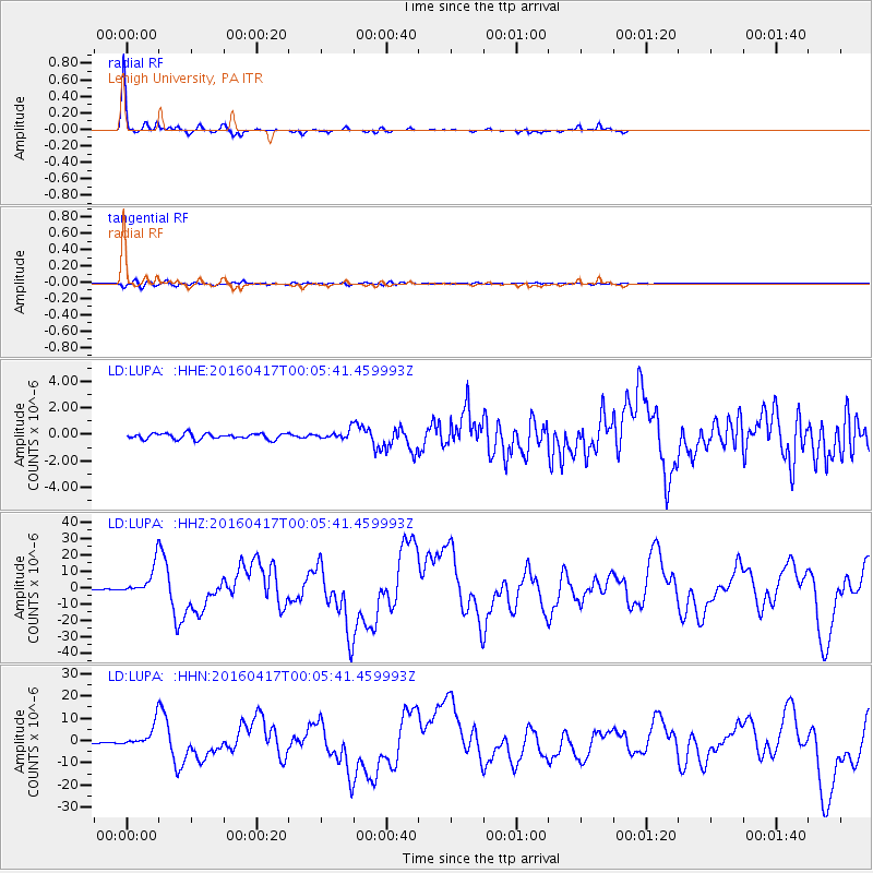
Signal To Noise
| Channel | StoN | STA | LTA |
| LD:LUPA: :HHZ:20160417T00:05:41.459993Z | 34.06776 | 9.514378E-6 | 2.7927805E-7 |
| LD:LUPA: :HHN:20160417T00:05:41.459993Z | 27.686905 | 5.5648593E-6 | 2.0099246E-7 |
| LD:LUPA: :HHE:20160417T00:05:41.459993Z | 2.2521527 | 4.852301E-7 | 2.1545168E-7 |
| Arrivals |
| Ps | 7.1 SECOND |
| PpPs | 21 SECOND |
| PsPs/PpSs | 28 SECOND |


