You are here: Home > Network List > LD - Lamont-Doherty Cooperative Seismographic Network Stations List
> Station PANJ Princeton, NJ > Earthquake Result Viewer
PANJ Princeton, NJ - Earthquake Result Viewer

| Earthquake location: |
Near Coast Of Ecuador |
| Earthquake latitude/longitude: |
0.4/-79.9 |
| Earthquake time(UTC): |
2016/04/16 (107) 23:58:37 GMT |
| Earthquake Depth: |
19 km |
| Earthquake Magnitude: |
7.8 MWW, 7.4 MI |
| Earthquake Catalog/Contributor: |
NEIC PDE/NEIC COMCAT |
|
| Network: |
LD Lamont-Doherty Cooperative Seismographic Network |
| Station: |
PANJ Princeton, NJ |
| Lat/Lon: |
40.38 N/74.70 W |
| Elevation: |
100 m |
|
| Distance: |
40.1 deg |
| Az: |
6.214 deg |
| Baz: |
188.146 deg |
| Ray Param: |
0.07456183 |
| Estimated Moho Depth: |
30.25 km |
| Estimated Crust Vp/Vs: |
2.01 |
| Assumed Crust Vp: |
6.283 km/s |
| Estimated Crust Vs: |
3.126 km/s |
| Estimated Crust Poisson's Ratio: |
0.34 |
|
| Radial Match: |
96.47266 % |
| Radial Bump: |
174 |
| Transverse Match: |
90.65625 % |
| Transverse Bump: |
400 |
| SOD ConfigId: |
7422571 |
| Insert Time: |
2019-04-22 08:02:40.629 +0000 |
| GWidth: |
2.5 |
| Max Bumps: |
400 |
| Tol: |
0.001 |
|
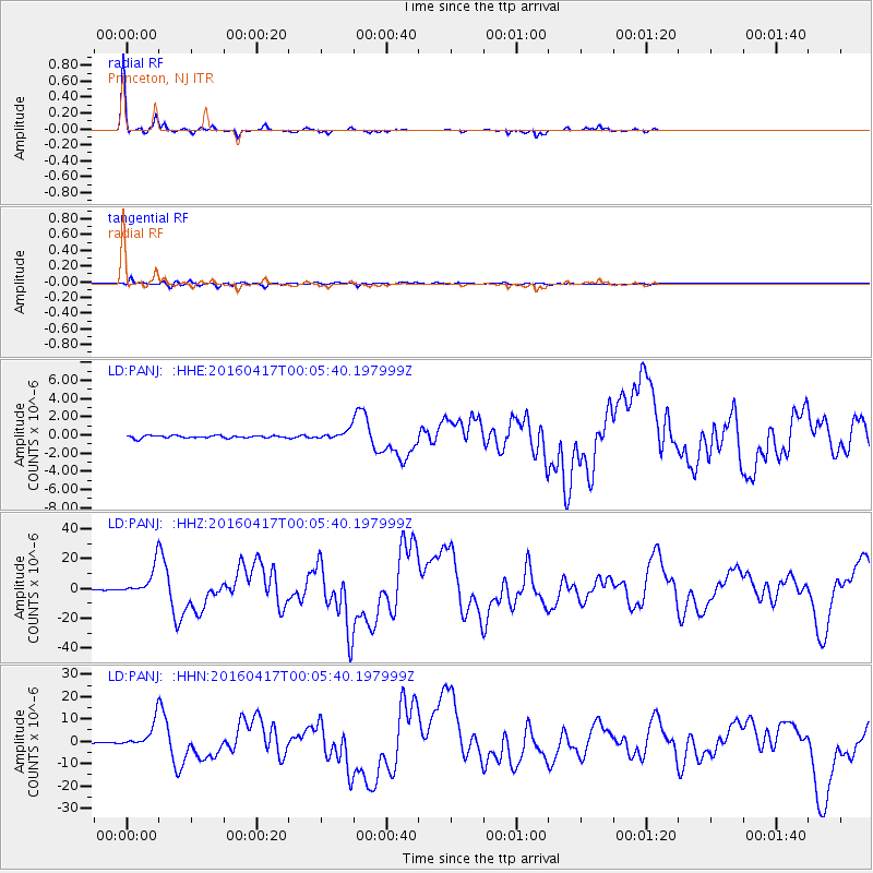
Signal To Noise
| Channel | StoN | STA | LTA |
| LD:PANJ: :HHZ:20160417T00:05:40.197999Z | 36.841187 | 1.0154245E-5 | 2.7562209E-7 |
| LD:PANJ: :HHN:20160417T00:05:40.197999Z | 26.59108 | 6.110415E-6 | 2.2979192E-7 |
| LD:PANJ: :HHE:20160417T00:05:40.197999Z | 7.031921 | 1.0168036E-6 | 1.4459827E-7 |
| Arrivals |
| Ps | 5.2 SECOND |
| PpPs | 14 SECOND |
| PsPs/PpSs | 19 SECOND |


