You are here: Home > Network List > N4 - Central and EAstern US Network Stations List
> Station 146B Union, MS, USA > Earthquake Result Viewer
146B Union, MS, USA - Earthquake Result Viewer
| Earthquake location: |
Near Coast Of Ecuador |
| Earthquake latitude/longitude: |
0.4/-79.9 |
| Earthquake time(UTC): |
2016/04/16 (107) 23:58:37 GMT |
| Earthquake Depth: |
19 km |
| Earthquake Magnitude: |
7.8 MWW, 7.4 MI |
| Earthquake Catalog/Contributor: |
NEIC PDE/NEIC COMCAT |
|
| Network: |
N4 Central and EAstern US Network |
| Station: |
146B Union, MS, USA |
| Lat/Lon: |
32.64 N/89.06 W |
| Elevation: |
161 m |
|
| Distance: |
33.2 deg |
| Az: |
345.877 deg |
| Baz: |
163.19 deg |
| Ray Param: |
0.07828607 |
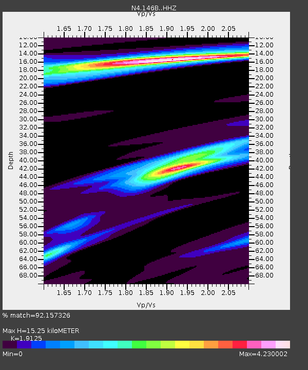
| Estimated Moho Depth: |
15.25 km |
| Estimated Crust Vp/Vs: |
1.91 |
| Assumed Crust Vp: |
6.201 km/s |
| Estimated Crust Vs: |
3.243 km/s |
| Estimated Crust Poisson's Ratio: |
0.31 |
|
| Radial Match: |
92.157326 % |
| Radial Bump: |
250 |
| Transverse Match: |
86.02304 % |
| Transverse Bump: |
400 |
| SOD ConfigId: |
7422571 |
| Insert Time: |
2019-04-22 08:02:59.010 +0000 |
| GWidth: |
2.5 |
| Max Bumps: |
400 |
| Tol: |
0.001 |
|

Signal To Noise
| Channel | StoN | STA | LTA |
| N4:146B: :HHZ:20160417T00:04:41.799989Z | 23.225742 | 7.968679E-6 | 3.4309684E-7 |
| N4:146B: :HHN:20160417T00:04:41.799989Z | 1.9876891 | 3.8351345E-6 | 1.9294437E-6 |
| N4:146B: :HHE:20160417T00:04:41.799989Z | 2.381518 | 1.4032632E-6 | 5.8923064E-7 |
| Arrivals |
| Ps | 2.4 SECOND |
| PpPs | 6.7 SECOND |
| PsPs/PpSs | 9.1 SECOND |


