You are here: Home > Network List > N4 - Central and EAstern US Network Stations List
> Station 553A Crawfordville, FL, USA > Earthquake Result Viewer
553A Crawfordville, FL, USA - Earthquake Result Viewer
| Earthquake location: |
Near Coast Of Ecuador |
| Earthquake latitude/longitude: |
0.4/-79.9 |
| Earthquake time(UTC): |
2016/04/16 (107) 23:58:37 GMT |
| Earthquake Depth: |
19 km |
| Earthquake Magnitude: |
7.8 MWW, 7.4 MI |
| Earthquake Catalog/Contributor: |
NEIC PDE/NEIC COMCAT |
|
| Network: |
N4 Central and EAstern US Network |
| Station: |
553A Crawfordville, FL, USA |
| Lat/Lon: |
30.19 N/84.43 W |
| Elevation: |
16 m |
|
| Distance: |
30.0 deg |
| Az: |
352.196 deg |
| Baz: |
170.977 deg |
| Ray Param: |
0.07944643 |
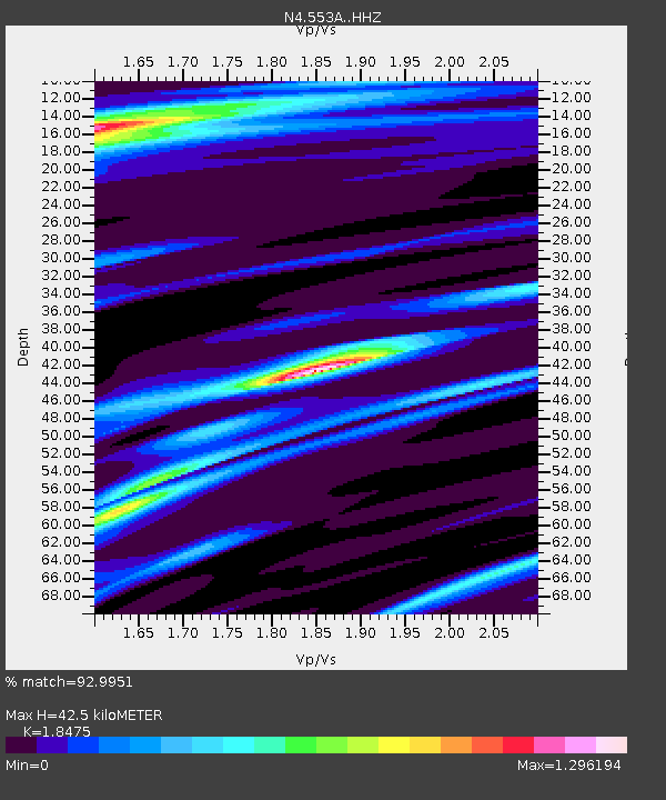
| Estimated Moho Depth: |
42.5 km |
| Estimated Crust Vp/Vs: |
1.85 |
| Assumed Crust Vp: |
6.347 km/s |
| Estimated Crust Vs: |
3.435 km/s |
| Estimated Crust Poisson's Ratio: |
0.29 |
|
| Radial Match: |
92.9951 % |
| Radial Bump: |
202 |
| Transverse Match: |
83.03762 % |
| Transverse Bump: |
400 |
| SOD ConfigId: |
7422571 |
| Insert Time: |
2019-04-22 08:03:09.940 +0000 |
| GWidth: |
2.5 |
| Max Bumps: |
400 |
| Tol: |
0.001 |
|

Signal To Noise
| Channel | StoN | STA | LTA |
| N4:553A: :HHZ:20160417T00:04:13.149995Z | 9.108999 | 1.018042E-5 | 1.1176222E-6 |
| N4:553A: :HHN:20160417T00:04:13.149995Z | 4.559176 | 3.5065973E-6 | 7.6912966E-7 |
| N4:553A: :HHE:20160417T00:04:13.149995Z | 0.41643992 | 3.2540322E-7 | 7.8139294E-7 |
| Arrivals |
| Ps | 6.1 SECOND |
| PpPs | 18 SECOND |
| PsPs/PpSs | 24 SECOND |


