You are here: Home > Network List > N4 - Central and EAstern US Network Stations List
> Station E28B Huff Hills, Mandan, ND, USA > Earthquake Result Viewer
E28B Huff Hills, Mandan, ND, USA - Earthquake Result Viewer
| Earthquake location: |
Near Coast Of Ecuador |
| Earthquake latitude/longitude: |
0.4/-79.9 |
| Earthquake time(UTC): |
2016/04/16 (107) 23:58:37 GMT |
| Earthquake Depth: |
19 km |
| Earthquake Magnitude: |
7.8 MWW, 7.4 MI |
| Earthquake Catalog/Contributor: |
NEIC PDE/NEIC COMCAT |
|
| Network: |
N4 Central and EAstern US Network |
| Station: |
E28B Huff Hills, Mandan, ND, USA |
| Lat/Lon: |
46.57 N/100.69 W |
| Elevation: |
704 m |
|
| Distance: |
49.5 deg |
| Az: |
341.242 deg |
| Baz: |
152.216 deg |
| Ray Param: |
0.06865137 |
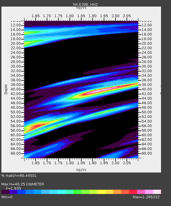
| Estimated Moho Depth: |
40.25 km |
| Estimated Crust Vp/Vs: |
1.93 |
| Assumed Crust Vp: |
6.438 km/s |
| Estimated Crust Vs: |
3.327 km/s |
| Estimated Crust Poisson's Ratio: |
0.32 |
|
| Radial Match: |
98.44501 % |
| Radial Bump: |
255 |
| Transverse Match: |
94.25189 % |
| Transverse Bump: |
310 |
| SOD ConfigId: |
7422571 |
| Insert Time: |
2019-04-22 08:03:13.760 +0000 |
| GWidth: |
2.5 |
| Max Bumps: |
400 |
| Tol: |
0.001 |
|

Signal To Noise
| Channel | StoN | STA | LTA |
| N4:E28B: :HHZ:20160417T00:06:54.850007Z | 48.43613 | 8.234493E-6 | 1.7000724E-7 |
| N4:E28B: :HHN:20160417T00:06:54.850007Z | 21.281214 | 5.3621206E-6 | 2.51965E-7 |
| N4:E28B: :HHE:20160417T00:06:54.850007Z | 8.286389 | 3.0896188E-6 | 3.7285463E-7 |
| Arrivals |
| Ps | 6.2 SECOND |
| PpPs | 17 SECOND |
| PsPs/PpSs | 24 SECOND |


