You are here: Home > Network List > N4 - Central and EAstern US Network Stations List
> Station K43A Burlington, WI, USA > Earthquake Result Viewer
K43A Burlington, WI, USA - Earthquake Result Viewer
| Earthquake location: |
Near Coast Of Ecuador |
| Earthquake latitude/longitude: |
0.4/-79.9 |
| Earthquake time(UTC): |
2016/04/16 (107) 23:58:37 GMT |
| Earthquake Depth: |
19 km |
| Earthquake Magnitude: |
7.8 MWW, 7.4 MI |
| Earthquake Catalog/Contributor: |
NEIC PDE/NEIC COMCAT |
|
| Network: |
N4 Central and EAstern US Network |
| Station: |
K43A Burlington, WI, USA |
| Lat/Lon: |
42.70 N/88.33 W |
| Elevation: |
264 m |
|
| Distance: |
42.8 deg |
| Az: |
350.892 deg |
| Baz: |
167.599 deg |
| Ray Param: |
0.0729251 |
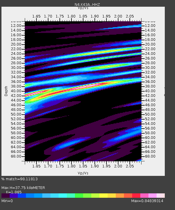
| Estimated Moho Depth: |
37.75 km |
| Estimated Crust Vp/Vs: |
1.87 |
| Assumed Crust Vp: |
6.571 km/s |
| Estimated Crust Vs: |
3.523 km/s |
| Estimated Crust Poisson's Ratio: |
0.30 |
|
| Radial Match: |
98.11813 % |
| Radial Bump: |
270 |
| Transverse Match: |
88.846634 % |
| Transverse Bump: |
400 |
| SOD ConfigId: |
7422571 |
| Insert Time: |
2019-04-22 08:03:36.724 +0000 |
| GWidth: |
2.5 |
| Max Bumps: |
400 |
| Tol: |
0.001 |
|

Signal To Noise
| Channel | StoN | STA | LTA |
| N4:K43A: :HHZ:20160417T00:06:02.450013Z | 25.221485 | 7.720061E-6 | 3.0609067E-7 |
| N4:K43A: :HHN:20160417T00:06:02.450013Z | 19.42068 | 4.326522E-6 | 2.2277911E-7 |
| N4:K43A: :HHE:20160417T00:06:02.450013Z | 5.3546395 | 1.1420994E-6 | 2.1329156E-7 |
| Arrivals |
| Ps | 5.3 SECOND |
| PpPs | 15 SECOND |
| PsPs/PpSs | 21 SECOND |


