You are here: Home > Network List > US - United States National Seismic Network Stations List
> Station NEW Newport, Washington, USA > Earthquake Result Viewer
NEW Newport, Washington, USA - Earthquake Result Viewer
| Earthquake location: |
South Of Panama |
| Earthquake latitude/longitude: |
7.9/-82.8 |
| Earthquake time(UTC): |
2002/07/31 (212) 00:16:44 GMT |
| Earthquake Depth: |
10 km |
| Earthquake Magnitude: |
6.0 MB, 6.4 MS, 6.5 MW, 6.4 MW |
| Earthquake Catalog/Contributor: |
WHDF/NEIC |
|
| Network: |
US United States National Seismic Network |
| Station: |
NEW Newport, Washington, USA |
| Lat/Lon: |
48.26 N/117.12 W |
| Elevation: |
760 m |
|
| Distance: |
49.6 deg |
| Az: |
330.327 deg |
| Baz: |
132.788 deg |
| Ray Param: |
0.06861878 |
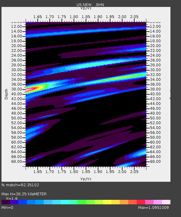
| Estimated Moho Depth: |
38.25 km |
| Estimated Crust Vp/Vs: |
1.60 |
| Assumed Crust Vp: |
6.571 km/s |
| Estimated Crust Vs: |
4.107 km/s |
| Estimated Crust Poisson's Ratio: |
0.18 |
|
| Radial Match: |
92.35102 % |
| Radial Bump: |
400 |
| Transverse Match: |
80.63291 % |
| Transverse Bump: |
400 |
| SOD ConfigId: |
110177 |
| Insert Time: |
2010-03-05 01:38:58.797 +0000 |
| GWidth: |
2.5 |
| Max Bumps: |
400 |
| Tol: |
0.001 |
|

Signal To Noise
| Channel | StoN | STA | LTA |
| US:NEW: :BHN:20020731T00:25:04.697006Z | 1.5960015 | 7.642351E-8 | 4.788436E-8 |
| US:NEW: :BHE:20020731T00:25:04.697006Z | 3.4453835 | 1.2544011E-7 | 3.640817E-8 |
| US:NEW: :BHZ:20020731T00:25:04.697006Z | 4.757199 | 2.7390902E-7 | 5.7577797E-8 |
| Arrivals |
| Ps | 3.7 SECOND |
| PpPs | 14 SECOND |
| PsPs/PpSs | 18 SECOND |


