You are here: Home > Network List > N4 - Central and EAstern US Network Stations List
> Station P61A Hammonton, NJ, USA > Earthquake Result Viewer
P61A Hammonton, NJ, USA - Earthquake Result Viewer
| Earthquake location: |
Near Coast Of Ecuador |
| Earthquake latitude/longitude: |
0.4/-79.9 |
| Earthquake time(UTC): |
2016/04/16 (107) 23:58:37 GMT |
| Earthquake Depth: |
19 km |
| Earthquake Magnitude: |
7.8 MWW, 7.4 MI |
| Earthquake Catalog/Contributor: |
NEIC PDE/NEIC COMCAT |
|
| Network: |
N4 Central and EAstern US Network |
| Station: |
P61A Hammonton, NJ, USA |
| Lat/Lon: |
39.67 N/74.79 W |
| Elevation: |
22 m |
|
| Distance: |
39.4 deg |
| Az: |
6.264 deg |
| Baz: |
188.127 deg |
| Ray Param: |
0.07498459 |
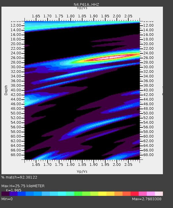
| Estimated Moho Depth: |
25.75 km |
| Estimated Crust Vp/Vs: |
1.97 |
| Assumed Crust Vp: |
6.287 km/s |
| Estimated Crust Vs: |
3.2 km/s |
| Estimated Crust Poisson's Ratio: |
0.33 |
|
| Radial Match: |
92.38122 % |
| Radial Bump: |
357 |
| Transverse Match: |
77.078094 % |
| Transverse Bump: |
400 |
| SOD ConfigId: |
7422571 |
| Insert Time: |
2019-04-22 08:04:08.001 +0000 |
| GWidth: |
2.5 |
| Max Bumps: |
400 |
| Tol: |
0.001 |
|
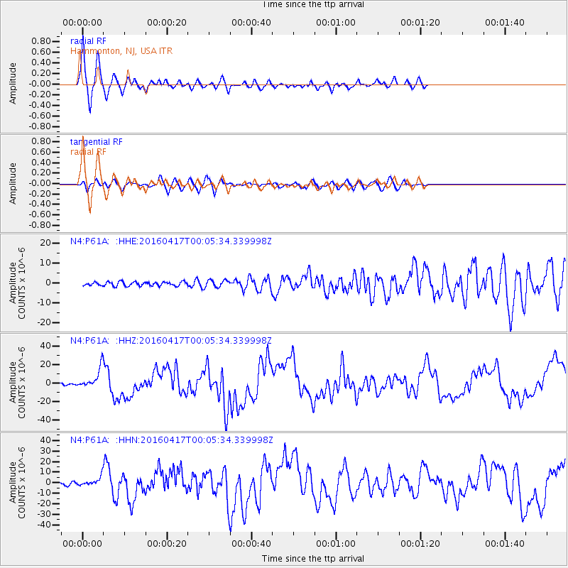
Signal To Noise
| Channel | StoN | STA | LTA |
| N4:P61A: :HHZ:20160417T00:05:34.339998Z | 18.684631 | 1.1807792E-5 | 6.3195216E-7 |
| N4:P61A: :HHN:20160417T00:05:34.339998Z | 3.1615222 | 4.5075367E-6 | 1.4257489E-6 |
| N4:P61A: :HHE:20160417T00:05:34.339998Z | 1.6822376 | 1.6723178E-6 | 9.941032E-7 |
| Arrivals |
| Ps | 4.2 SECOND |
| PpPs | 11 SECOND |
| PsPs/PpSs | 16 SECOND |


