You are here: Home > Network List > NN - Western Great Basin/Eastern Sierra Nevada Stations List
> Station COLR Coleman Ranch, NV portable > Earthquake Result Viewer
COLR Coleman Ranch, NV portable - Earthquake Result Viewer
| Earthquake location: |
Near Coast Of Ecuador |
| Earthquake latitude/longitude: |
0.4/-79.9 |
| Earthquake time(UTC): |
2016/04/16 (107) 23:58:37 GMT |
| Earthquake Depth: |
19 km |
| Earthquake Magnitude: |
7.8 MWW, 7.4 MI |
| Earthquake Catalog/Contributor: |
NEIC PDE/NEIC COMCAT |
|
| Network: |
NN Western Great Basin/Eastern Sierra Nevada |
| Station: |
COLR Coleman Ranch, NV portable |
| Lat/Lon: |
41.96 N/119.79 W |
| Elevation: |
1482 m |
|
| Distance: |
54.8 deg |
| Az: |
324.189 deg |
| Baz: |
128.328 deg |
| Ray Param: |
0.065216385 |
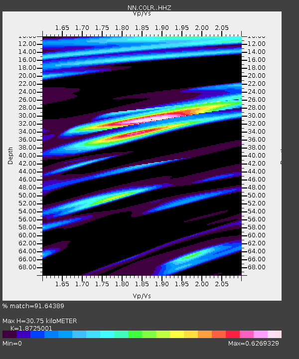
| Estimated Moho Depth: |
30.75 km |
| Estimated Crust Vp/Vs: |
1.87 |
| Assumed Crust Vp: |
6.276 km/s |
| Estimated Crust Vs: |
3.352 km/s |
| Estimated Crust Poisson's Ratio: |
0.30 |
|
| Radial Match: |
91.64389 % |
| Radial Bump: |
324 |
| Transverse Match: |
86.97982 % |
| Transverse Bump: |
400 |
| SOD ConfigId: |
7422571 |
| Insert Time: |
2019-04-22 08:05:06.336 +0000 |
| GWidth: |
2.5 |
| Max Bumps: |
400 |
| Tol: |
0.001 |
|

Signal To Noise
| Channel | StoN | STA | LTA |
| NN:COLR: :HHZ:20160417T00:07:34.160005Z | 6.3043423 | 7.625992E-7 | 1.2096412E-7 |
| NN:COLR: :HHN:20160417T00:07:34.160005Z | 1.1428392 | 4.0240357E-7 | 3.5210866E-7 |
| NN:COLR: :HHE:20160417T00:07:34.160005Z | 2.4547875 | 4.5638396E-7 | 1.8591588E-7 |
| Arrivals |
| Ps | 4.5 SECOND |
| PpPs | 13 SECOND |
| PsPs/PpSs | 18 SECOND |


