NEW Newport, Washington, USA - Earthquake Result Viewer
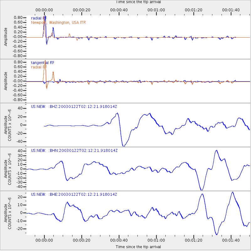
Earthquake location: Near Coast Of Jalisco, Mexico
Earthquake latitude/longitude: 18.8/-104.1
Earthquake time(UTC): 2003/01/22 (022) 02:06:34 GMT
Earthquake Depth: 24 km
Earthquake Magnitude: 6.5 MB, 7.6 MS, 7.6 MW, 7.4 MW
Earthquake Catalog/Contributor: WHDF/NEIC
Network: US United States National Seismic Network
Station: NEW Newport, Washington, USA
Lat/Lon: 48.26 N/117.12 W
Elevation: 760 m
Distance: 31.3 deg
Az: 343.143 deg
Baz: 155.721 deg
Ray Param: 0.079097085
Estimated Moho Depth: 41.25 km
Estimated Crust Vp/Vs: 1.71
Assumed Crust Vp: 6.571 km/s
Estimated Crust Vs: 3.837 km/s
Estimated Crust Poisson's Ratio: 0.24
Radial Match: 92.72761 %
Radial Bump: 223
Transverse Match: 72.393 %
Transverse Bump: 400
SOD ConfigId: 110177
Insert Time: 2010-03-05 01:39:33.344 +0000
GWidth: 2.5
Max Bumps: 400
Tol: 0.001

Signal To Noise

ChannelStoNSTALTA
US:NEW: :BHN:20030122T02:12:21.918014Z2.9177522.145064E-67.3517697E-7
US:NEW: :BHE:20030122T02:12:21.918014Z1.71647121.0602591E-66.17697E-7
US:NEW: :BHZ:20030122T02:12:21.918014Z7.0886314.256586E-66.004807E-7
Arrivals
Ps4.9 SECOND
PpPs16 SECOND
PsPs/PpSs20 SECOND