You are here: Home > Network List > NY - Yukon Northwest Seismic Network(YNSN) Stations List
> Station MMPY Sheldon Lake, Yukon, CANADA > Earthquake Result Viewer
MMPY Sheldon Lake, Yukon, CANADA - Earthquake Result Viewer
| Earthquake location: |
Near Coast Of Ecuador |
| Earthquake latitude/longitude: |
0.4/-79.9 |
| Earthquake time(UTC): |
2016/04/16 (107) 23:58:37 GMT |
| Earthquake Depth: |
19 km |
| Earthquake Magnitude: |
7.8 MWW, 7.4 MI |
| Earthquake Catalog/Contributor: |
NEIC PDE/NEIC COMCAT |
|
| Network: |
NY Yukon Northwest Seismic Network(YNSN) |
| Station: |
MMPY Sheldon Lake, Yukon, CANADA |
| Lat/Lon: |
62.62 N/131.26 W |
| Elevation: |
0.0 m |
|
| Distance: |
72.9 deg |
| Az: |
337.808 deg |
| Baz: |
125.222 deg |
| Ray Param: |
0.05336307 |
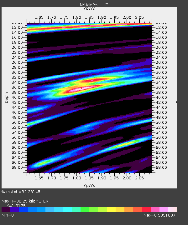
| Estimated Moho Depth: |
36.25 km |
| Estimated Crust Vp/Vs: |
1.82 |
| Assumed Crust Vp: |
6.419 km/s |
| Estimated Crust Vs: |
3.532 km/s |
| Estimated Crust Poisson's Ratio: |
0.28 |
|
| Radial Match: |
92.33145 % |
| Radial Bump: |
400 |
| Transverse Match: |
79.87415 % |
| Transverse Bump: |
400 |
| SOD ConfigId: |
7422571 |
| Insert Time: |
2019-04-22 08:05:30.143 +0000 |
| GWidth: |
2.5 |
| Max Bumps: |
400 |
| Tol: |
0.001 |
|

Signal To Noise
| Channel | StoN | STA | LTA |
| NY:MMPY: :HHZ:20160417T00:09:33.060029Z | 42.973225 | 4.1077337E-6 | 9.558822E-8 |
| NY:MMPY: :HHN:20160417T00:09:33.060029Z | 5.2290974 | 5.252312E-7 | 1.0044395E-7 |
| NY:MMPY: :HHE:20160417T00:09:33.060029Z | 7.595672 | 1.0829657E-6 | 1.4257668E-7 |
| Arrivals |
| Ps | 4.8 SECOND |
| PpPs | 15 SECOND |
| PsPs/PpSs | 20 SECOND |


