You are here: Home > Network List > OK - Oklahoma Seismic Network Stations List
> Station BCOK Bluff Creek, North Oklahoma City, Oklahoma > Earthquake Result Viewer
BCOK Bluff Creek, North Oklahoma City, Oklahoma - Earthquake Result Viewer
| Earthquake location: |
Near Coast Of Ecuador |
| Earthquake latitude/longitude: |
0.4/-79.9 |
| Earthquake time(UTC): |
2016/04/16 (107) 23:58:37 GMT |
| Earthquake Depth: |
19 km |
| Earthquake Magnitude: |
7.8 MWW, 7.4 MI |
| Earthquake Catalog/Contributor: |
NEIC PDE/NEIC COMCAT |
|
| Network: |
OK Oklahoma Seismic Network |
| Station: |
BCOK Bluff Creek, North Oklahoma City, Oklahoma |
| Lat/Lon: |
35.66 N/97.61 W |
| Elevation: |
302 m |
|
| Distance: |
38.8 deg |
| Az: |
336.75 deg |
| Baz: |
151.006 deg |
| Ray Param: |
0.07534722 |
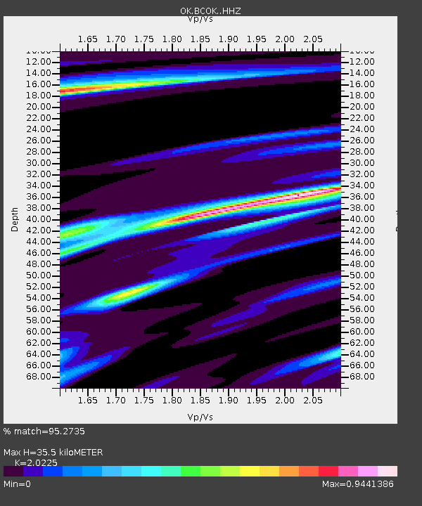
| Estimated Moho Depth: |
35.5 km |
| Estimated Crust Vp/Vs: |
2.02 |
| Assumed Crust Vp: |
6.426 km/s |
| Estimated Crust Vs: |
3.177 km/s |
| Estimated Crust Poisson's Ratio: |
0.34 |
|
| Radial Match: |
95.2735 % |
| Radial Bump: |
284 |
| Transverse Match: |
82.59517 % |
| Transverse Bump: |
400 |
| SOD ConfigId: |
7422571 |
| Insert Time: |
2019-04-22 08:05:31.361 +0000 |
| GWidth: |
2.5 |
| Max Bumps: |
400 |
| Tol: |
0.001 |
|

Signal To Noise
| Channel | StoN | STA | LTA |
| OK:BCOK: :HHZ:20160417T00:05:29.183992Z | 13.94592 | 3.2319372E-6 | 2.3174786E-7 |
| OK:BCOK: :HHN:20160417T00:05:29.183992Z | 3.9428706 | 1.7758426E-6 | 4.5039332E-7 |
| OK:BCOK: :HHE:20160417T00:05:29.183992Z | 3.3875675 | 1.2609695E-6 | 3.7223452E-7 |
| Arrivals |
| Ps | 6.0 SECOND |
| PpPs | 16 SECOND |
| PsPs/PpSs | 22 SECOND |


