You are here: Home > Network List > PE - Penn State Network Stations List
> Station PSUB Penn State - Brandywine Campus > Earthquake Result Viewer
PSUB Penn State - Brandywine Campus - Earthquake Result Viewer
| Earthquake location: |
Near Coast Of Ecuador |
| Earthquake latitude/longitude: |
0.4/-79.9 |
| Earthquake time(UTC): |
2016/04/16 (107) 23:58:37 GMT |
| Earthquake Depth: |
19 km |
| Earthquake Magnitude: |
7.8 MWW, 7.4 MI |
| Earthquake Catalog/Contributor: |
NEIC PDE/NEIC COMCAT |
|
| Network: |
PE Penn State Network |
| Station: |
PSUB Penn State - Brandywine Campus |
| Lat/Lon: |
39.93 N/75.45 W |
| Elevation: |
110 m |
|
| Distance: |
39.6 deg |
| Az: |
5.419 deg |
| Baz: |
187.055 deg |
| Ray Param: |
0.07487817 |
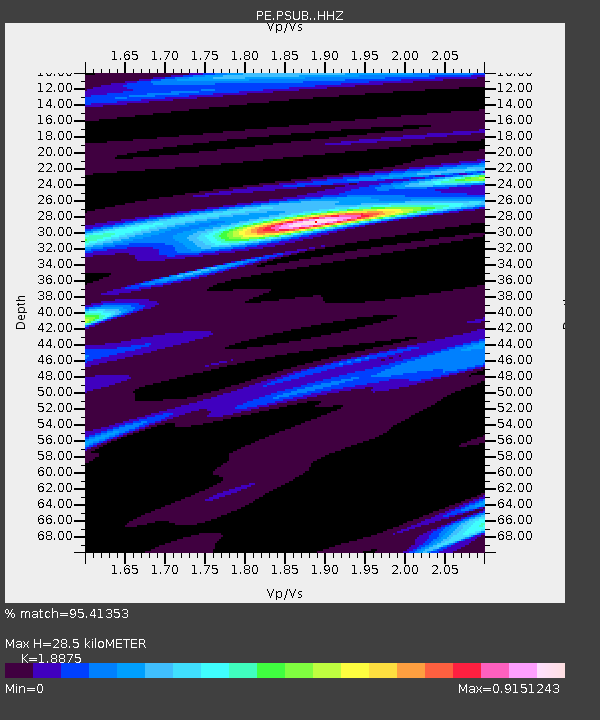
| Estimated Moho Depth: |
28.5 km |
| Estimated Crust Vp/Vs: |
1.89 |
| Assumed Crust Vp: |
6.287 km/s |
| Estimated Crust Vs: |
3.331 km/s |
| Estimated Crust Poisson's Ratio: |
0.30 |
|
| Radial Match: |
95.41353 % |
| Radial Bump: |
262 |
| Transverse Match: |
82.78658 % |
| Transverse Bump: |
400 |
| SOD ConfigId: |
7422571 |
| Insert Time: |
2019-04-22 08:06:10.227 +0000 |
| GWidth: |
2.5 |
| Max Bumps: |
400 |
| Tol: |
0.001 |
|

Signal To Noise
| Channel | StoN | STA | LTA |
| PE:PSUB: :HHZ:20160417T00:05:35.899995Z | 39.986935 | 1.558688E-5 | 3.8979934E-7 |
| PE:PSUB: :HHN:20160417T00:05:35.899995Z | 33.310196 | 9.753293E-6 | 2.9280204E-7 |
| PE:PSUB: :HHE:20160417T00:05:35.899995Z | 4.165286 | 1.1385243E-6 | 2.733364E-7 |
| Arrivals |
| Ps | 4.3 SECOND |
| PpPs | 12 SECOND |
| PsPs/PpSs | 17 SECOND |


