You are here: Home > Network List > PM - Portuguese National Seismic Network Stations List
> Station PFVI PM.PFVI > Earthquake Result Viewer
PFVI PM.PFVI - Earthquake Result Viewer
| Earthquake location: |
Near Coast Of Ecuador |
| Earthquake latitude/longitude: |
0.4/-79.9 |
| Earthquake time(UTC): |
2016/04/16 (107) 23:58:37 GMT |
| Earthquake Depth: |
19 km |
| Earthquake Magnitude: |
7.8 MWW, 7.4 MI |
| Earthquake Catalog/Contributor: |
NEIC PDE/NEIC COMCAT |
|
| Network: |
PM Portuguese National Seismic Network |
| Station: |
PFVI PM.PFVI |
| Lat/Lon: |
37.13 N/8.83 W |
| Elevation: |
189 m |
|
| Distance: |
74.8 deg |
| Az: |
51.596 deg |
| Baz: |
258.679 deg |
| Ray Param: |
0.052087385 |
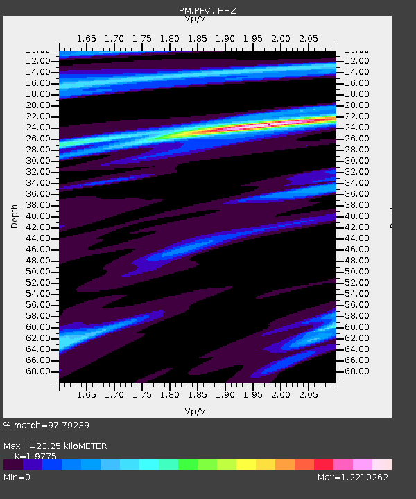
| Estimated Moho Depth: |
23.25 km |
| Estimated Crust Vp/Vs: |
1.98 |
| Assumed Crust Vp: |
6.048 km/s |
| Estimated Crust Vs: |
3.058 km/s |
| Estimated Crust Poisson's Ratio: |
0.33 |
|
| Radial Match: |
97.79239 % |
| Radial Bump: |
317 |
| Transverse Match: |
92.67496 % |
| Transverse Bump: |
400 |
| SOD ConfigId: |
7422571 |
| Insert Time: |
2019-04-22 08:06:17.885 +0000 |
| GWidth: |
2.5 |
| Max Bumps: |
400 |
| Tol: |
0.001 |
|

Signal To Noise
| Channel | StoN | STA | LTA |
| PM:PFVI: :HHZ:20160417T00:09:44.139985Z | 16.578022 | 5.6055137E-6 | 3.3812924E-7 |
| PM:PFVI: :HHN:20160417T00:09:44.139985Z | 2.1589036 | 6.58632E-7 | 3.050771E-7 |
| PM:PFVI: :HHE:20160417T00:09:44.139985Z | 6.0545955 | 1.8974538E-6 | 3.1339067E-7 |
| Arrivals |
| Ps | 3.9 SECOND |
| PpPs | 11 SECOND |
| PsPs/PpSs | 15 SECOND |


