You are here: Home > Network List > RV - Regional Alberta Seismic Observatory for Earthquake Studies Network Stations List
> Station LGPLA Lodgepole, Alberta > Earthquake Result Viewer
LGPLA Lodgepole, Alberta - Earthquake Result Viewer
| Earthquake location: |
Near Coast Of Ecuador |
| Earthquake latitude/longitude: |
0.4/-79.9 |
| Earthquake time(UTC): |
2016/04/16 (107) 23:58:37 GMT |
| Earthquake Depth: |
19 km |
| Earthquake Magnitude: |
7.8 MWW, 7.4 MI |
| Earthquake Catalog/Contributor: |
NEIC PDE/NEIC COMCAT |
|
| Network: |
RV Regional Alberta Seismic Observatory for Earthquake Studies Network |
| Station: |
LGPLA Lodgepole, Alberta |
| Lat/Lon: |
53.12 N/115.36 W |
| Elevation: |
877 m |
|
| Distance: |
60.2 deg |
| Az: |
336.273 deg |
| Baz: |
138.124 deg |
| Ray Param: |
0.06164234 |
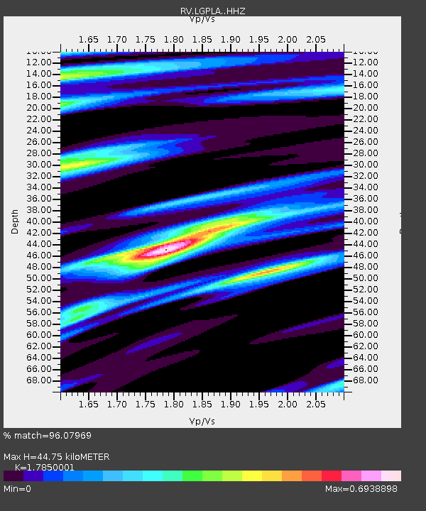
| Estimated Moho Depth: |
44.75 km |
| Estimated Crust Vp/Vs: |
1.79 |
| Assumed Crust Vp: |
6.426 km/s |
| Estimated Crust Vs: |
3.6 km/s |
| Estimated Crust Poisson's Ratio: |
0.27 |
|
| Radial Match: |
96.07969 % |
| Radial Bump: |
281 |
| Transverse Match: |
83.93056 % |
| Transverse Bump: |
400 |
| SOD ConfigId: |
7422571 |
| Insert Time: |
2019-04-22 08:06:40.283 +0000 |
| GWidth: |
2.5 |
| Max Bumps: |
400 |
| Tol: |
0.001 |
|

Signal To Noise
| Channel | StoN | STA | LTA |
| RV:LGPLA: :HHZ:20160417T00:08:12.600007Z | 23.388508 | 5.831461E-6 | 2.4933018E-7 |
| RV:LGPLA: :HHN:20160417T00:08:12.600007Z | 6.210821 | 1.8236306E-6 | 2.936215E-7 |
| RV:LGPLA: :HHE:20160417T00:08:12.600007Z | 5.5461946 | 1.7699508E-6 | 3.1912887E-7 |
| Arrivals |
| Ps | 5.7 SECOND |
| PpPs | 19 SECOND |
| PsPs/PpSs | 24 SECOND |


