You are here: Home > Network List > RV - Regional Alberta Seismic Observatory for Earthquake Studies Network Stations List
> Station BRLDA Berland Lookout Tower, AB > Earthquake Result Viewer
BRLDA Berland Lookout Tower, AB - Earthquake Result Viewer
| Earthquake location: |
Near Coast Of Ecuador |
| Earthquake latitude/longitude: |
0.4/-79.9 |
| Earthquake time(UTC): |
2016/04/16 (107) 23:58:37 GMT |
| Earthquake Depth: |
19 km |
| Earthquake Magnitude: |
7.8 MWW, 7.4 MI |
| Earthquake Catalog/Contributor: |
NEIC PDE/NEIC COMCAT |
|
| Network: |
RV Regional Alberta Seismic Observatory for Earthquake Studies Network |
| Station: |
BRLDA Berland Lookout Tower, AB |
| Lat/Lon: |
54.09 N/117.40 W |
| Elevation: |
1224 m |
|
| Distance: |
61.8 deg |
| Az: |
336.008 deg |
| Baz: |
136.35 deg |
| Ray Param: |
0.06063271 |
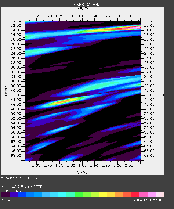
| Estimated Moho Depth: |
12.5 km |
| Estimated Crust Vp/Vs: |
2.10 |
| Assumed Crust Vp: |
6.426 km/s |
| Estimated Crust Vs: |
3.064 km/s |
| Estimated Crust Poisson's Ratio: |
0.35 |
|
| Radial Match: |
96.00267 % |
| Radial Bump: |
400 |
| Transverse Match: |
81.42244 % |
| Transverse Bump: |
400 |
| SOD ConfigId: |
7422571 |
| Insert Time: |
2019-04-22 08:06:40.371 +0000 |
| GWidth: |
2.5 |
| Max Bumps: |
400 |
| Tol: |
0.001 |
|

Signal To Noise
| Channel | StoN | STA | LTA |
| RV:BRLDA: :HHZ:20160417T00:08:23.079988Z | 26.856054 | 5.6472086E-6 | 2.1027692E-7 |
| RV:BRLDA: :HHN:20160417T00:08:23.079988Z | 5.21368 | 2.2081697E-6 | 4.2353383E-7 |
| RV:BRLDA: :HHE:20160417T00:08:23.079988Z | 4.562699 | 2.0746497E-6 | 4.5469795E-7 |
| Arrivals |
| Ps | 2.2 SECOND |
| PpPs | 5.8 SECOND |
| PsPs/PpSs | 8.0 SECOND |


