You are here: Home > Network List > SN - Southern Great Basin Network Stations List
> Station HEL Hell's Gate, California w84 > Earthquake Result Viewer
HEL Hell's Gate, California w84 - Earthquake Result Viewer
| Earthquake location: |
Near Coast Of Ecuador |
| Earthquake latitude/longitude: |
0.4/-79.9 |
| Earthquake time(UTC): |
2016/04/16 (107) 23:58:37 GMT |
| Earthquake Depth: |
19 km |
| Earthquake Magnitude: |
7.8 MWW, 7.4 MI |
| Earthquake Catalog/Contributor: |
NEIC PDE/NEIC COMCAT |
|
| Network: |
SN Southern Great Basin Network |
| Station: |
HEL Hell's Gate, California w84 |
| Lat/Lon: |
36.72 N/116.98 W |
| Elevation: |
747 m |
|
| Distance: |
49.8 deg |
| Az: |
320.7 deg |
| Baz: |
127.971 deg |
| Ray Param: |
0.06843371 |
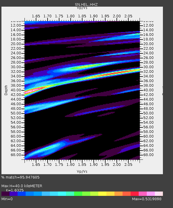
| Estimated Moho Depth: |
40.0 km |
| Estimated Crust Vp/Vs: |
1.63 |
| Assumed Crust Vp: |
6.279 km/s |
| Estimated Crust Vs: |
3.846 km/s |
| Estimated Crust Poisson's Ratio: |
0.20 |
|
| Radial Match: |
95.947685 % |
| Radial Bump: |
284 |
| Transverse Match: |
90.05627 % |
| Transverse Bump: |
400 |
| SOD ConfigId: |
7422571 |
| Insert Time: |
2019-04-22 08:06:49.592 +0000 |
| GWidth: |
2.5 |
| Max Bumps: |
400 |
| Tol: |
0.001 |
|

Signal To Noise
| Channel | StoN | STA | LTA |
| SN:HEL: :HHZ:20160417T00:06:57.507997Z | 1.4475403 | 5.2903385E-7 | 3.6547092E-7 |
| SN:HEL: :HHN:20160417T00:06:57.507997Z | 3.8213243 | 8.601139E-7 | 2.2508267E-7 |
| SN:HEL: :HHE:20160417T00:06:57.507997Z | 4.760281 | 8.451631E-7 | 1.7754479E-7 |
| Arrivals |
| Ps | 4.3 SECOND |
| PpPs | 16 SECOND |
| PsPs/PpSs | 20 SECOND |


