You are here: Home > Network List > TA - USArray Transportable Network (new EarthScope stations) Stations List
> Station C06D Leavenworth, WQ, USA > Earthquake Result Viewer
C06D Leavenworth, WQ, USA - Earthquake Result Viewer
| Earthquake location: |
Near Coast Of Ecuador |
| Earthquake latitude/longitude: |
0.4/-79.9 |
| Earthquake time(UTC): |
2016/04/16 (107) 23:58:37 GMT |
| Earthquake Depth: |
19 km |
| Earthquake Magnitude: |
7.8 MWW, 7.4 MI |
| Earthquake Catalog/Contributor: |
NEIC PDE/NEIC COMCAT |
|
| Network: |
TA USArray Transportable Network (new EarthScope stations) |
| Station: |
C06D Leavenworth, WQ, USA |
| Lat/Lon: |
47.92 N/120.89 W |
| Elevation: |
544 m |
|
| Distance: |
59.2 deg |
| Az: |
329.103 deg |
| Baz: |
130.232 deg |
| Ray Param: |
0.06235485 |
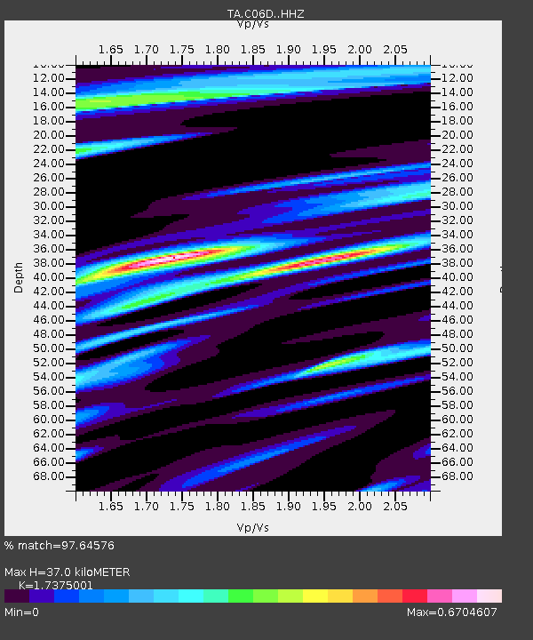
| Estimated Moho Depth: |
37.0 km |
| Estimated Crust Vp/Vs: |
1.74 |
| Assumed Crust Vp: |
6.597 km/s |
| Estimated Crust Vs: |
3.797 km/s |
| Estimated Crust Poisson's Ratio: |
0.25 |
|
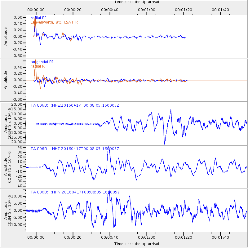
| Radial Match: |
97.64576 % |
| Radial Bump: |
287 |
| Transverse Match: |
83.813736 % |
| Transverse Bump: |
400 |
| SOD ConfigId: |
7422571 |
| Insert Time: |
2019-04-22 08:07:03.829 +0000 |
| GWidth: |
2.5 |
| Max Bumps: |
400 |
| Tol: |
0.001 |
|
Signal To Noise
| Channel | StoN | STA | LTA |
| TA:C06D: :HHZ:20160417T00:08:05.160005Z | 13.5776825 | 2.4710214E-6 | 1.8199141E-7 |
| TA:C06D: :HHN:20160417T00:08:05.160005Z | 3.0938768 | 7.881743E-7 | 2.5475296E-7 |
| TA:C06D: :HHE:20160417T00:08:05.160005Z | 4.131039 | 9.251283E-7 | 2.2394568E-7 |
| Arrivals |
| Ps | 4.4 SECOND |
| PpPs | 15 SECOND |
| PsPs/PpSs | 19 SECOND |


