You are here: Home > Network List > TA - USArray Transportable Network (new EarthScope stations) Stations List
> Station J01E Myrtle Point, OR, USA > Earthquake Result Viewer
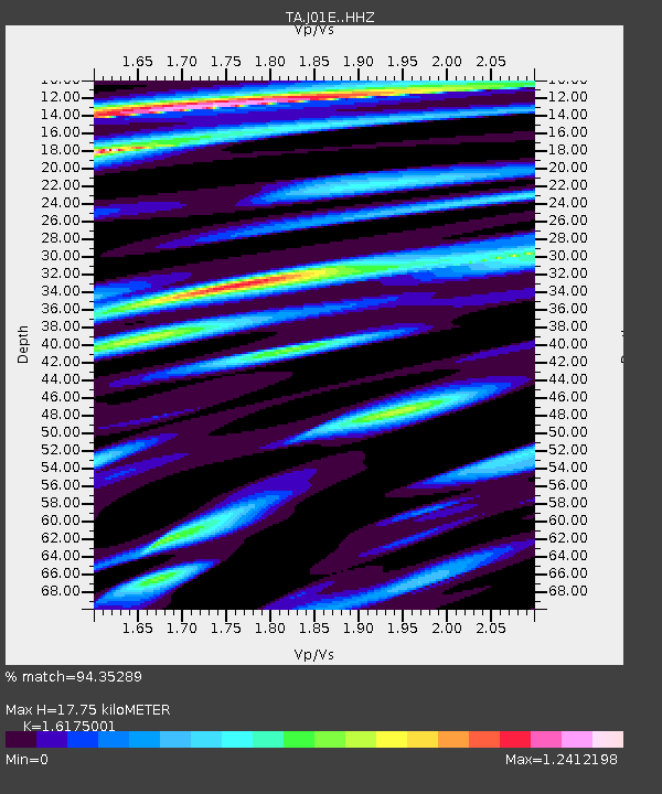
J01E Myrtle Point, OR, USA - Earthquake Result Viewer
| Earthquake location: |
Near Coast Of Ecuador |
| Earthquake latitude/longitude: |
0.4/-79.9 |
| Earthquake time(UTC): |
2016/04/16 (107) 23:58:37 GMT |
| Earthquake Depth: |
19 km |
| Earthquake Magnitude: |
7.8 MWW, 7.4 MI |
| Earthquake Catalog/Contributor: |
NEIC PDE/NEIC COMCAT |
|
| Network: |
TA USArray Transportable Network (new EarthScope stations) |
| Station: |
J01E Myrtle Point, OR, USA |
| Lat/Lon: |
43.16 N/123.93 W |
| Elevation: |
128 m |
|
| Distance: |
57.9 deg |
| Az: |
323.154 deg |
| Baz: |
124.963 deg |
| Ray Param: |
0.06314772 |
| Estimated Moho Depth: |
17.75 km |
| Estimated Crust Vp/Vs: |
1.62 |
| Assumed Crust Vp: |
6.522 km/s |
| Estimated Crust Vs: |
4.032 km/s |
| Estimated Crust Poisson's Ratio: |
0.19 |
|
| Radial Match: |
94.35289 % |
| Radial Bump: |
400 |
| Transverse Match: |
90.4328 % |
| Transverse Bump: |
400 |
| SOD ConfigId: |
7422571 |
| Insert Time: |
2019-04-22 08:07:25.411 +0000 |
| GWidth: |
2.5 |
| Max Bumps: |
400 |
| Tol: |
0.001 |
|

Signal To Noise
| Channel | StoN | STA | LTA |
| TA:J01E: :HHZ:20160417T00:07:56.730012Z | 3.2053437 | 1.5416317E-6 | 4.8095677E-7 |
| TA:J01E: :HHN:20160417T00:07:56.730012Z | 1.4395015 | 6.018748E-7 | 4.1811336E-7 |
| TA:J01E: :HHE:20160417T00:07:56.730012Z | 2.0286553 | 8.1695265E-7 | 4.027065E-7 |
| Arrivals |
| Ps | 1.8 SECOND |
| PpPs | 6.7 SECOND |
| PsPs/PpSs | 8.5 SECOND |


