You are here: Home > Network List > TA - USArray Transportable Network (new EarthScope stations) Stations List
> Station L04D Klamath Falls, OR, USA > Earthquake Result Viewer
L04D Klamath Falls, OR, USA - Earthquake Result Viewer
| Earthquake location: |
Near Coast Of Ecuador |
| Earthquake latitude/longitude: |
0.4/-79.9 |
| Earthquake time(UTC): |
2016/04/16 (107) 23:58:37 GMT |
| Earthquake Depth: |
19 km |
| Earthquake Magnitude: |
7.8 MWW, 7.4 MI |
| Earthquake Catalog/Contributor: |
NEIC PDE/NEIC COMCAT |
|
| Network: |
TA USArray Transportable Network (new EarthScope stations) |
| Station: |
L04D Klamath Falls, OR, USA |
| Lat/Lon: |
42.22 N/122.30 W |
| Elevation: |
1437 m |
|
| Distance: |
56.4 deg |
| Az: |
323.069 deg |
| Baz: |
126.016 deg |
| Ray Param: |
0.06413458 |
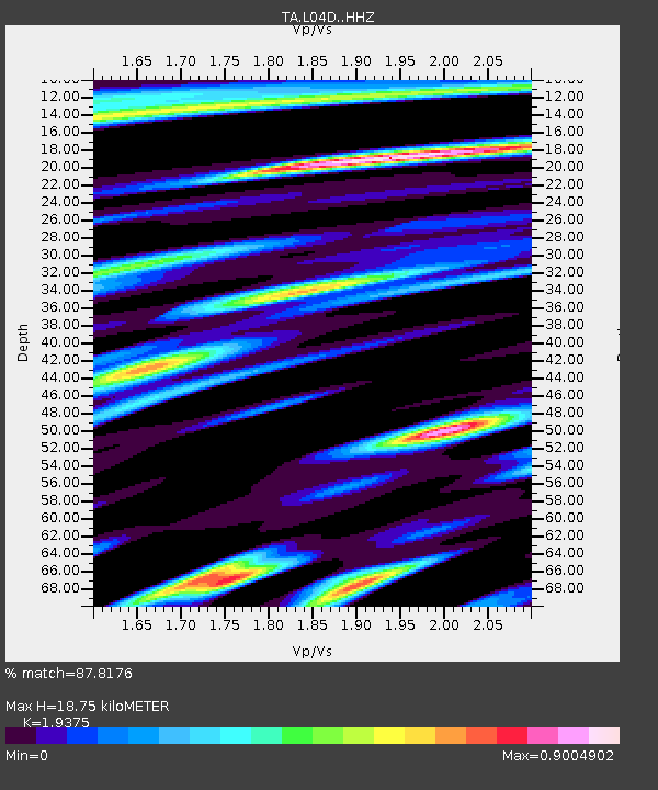
| Estimated Moho Depth: |
18.75 km |
| Estimated Crust Vp/Vs: |
1.94 |
| Assumed Crust Vp: |
6.522 km/s |
| Estimated Crust Vs: |
3.366 km/s |
| Estimated Crust Poisson's Ratio: |
0.32 |
|
| Radial Match: |
87.8176 % |
| Radial Bump: |
400 |
| Transverse Match: |
81.26302 % |
| Transverse Bump: |
400 |
| SOD ConfigId: |
7422571 |
| Insert Time: |
2019-04-22 08:07:33.557 +0000 |
| GWidth: |
2.5 |
| Max Bumps: |
400 |
| Tol: |
0.001 |
|
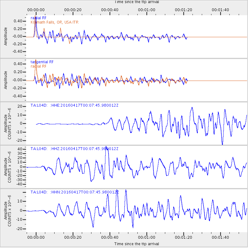
Signal To Noise
| Channel | StoN | STA | LTA |
| TA:L04D: :HHZ:20160417T00:07:45.980012Z | 4.004021 | 1.2420098E-6 | 3.1019061E-7 |
| TA:L04D: :HHN:20160417T00:07:45.980012Z | 1.7577281 | 4.6920206E-7 | 2.6693667E-7 |
| TA:L04D: :HHE:20160417T00:07:45.980012Z | 2.3138397 | 5.874954E-7 | 2.5390497E-7 |
| Arrivals |
| Ps | 2.8 SECOND |
| PpPs | 8.1 SECOND |
| PsPs/PpSs | 11 SECOND |


