NEW Newport, Washington, USA - Earthquake Result Viewer
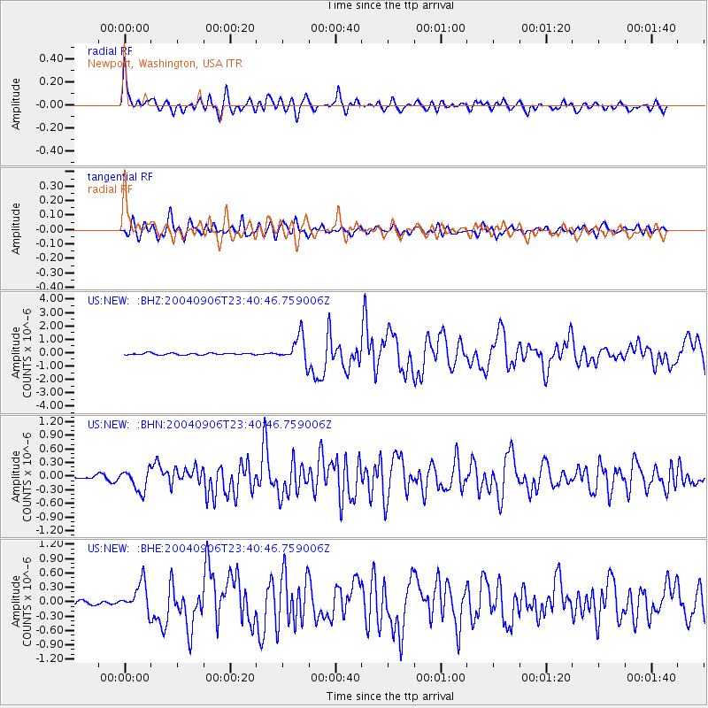
Earthquake location: Near S. Coast Of Honshu, Japan
Earthquake latitude/longitude: 33.2/137.2
Earthquake time(UTC): 2004/09/06 (250) 23:29:35 GMT
Earthquake Depth: 10 km
Earthquake Magnitude: 6.4 MB, 6.3 MS, 6.7 MW, 6.5 MW
Earthquake Catalog/Contributor: WHDF/NEIC
Network: US United States National Seismic Network
Station: NEW Newport, Washington, USA
Lat/Lon: 48.26 N/117.12 W
Elevation: 760 m
Distance: 75.3 deg
Az: 41.705 deg
Baz: 303.409 deg
Ray Param: 0.051786333
Estimated Moho Depth: 48.75 km
Estimated Crust Vp/Vs: 1.71
Assumed Crust Vp: 6.571 km/s
Estimated Crust Vs: 3.837 km/s
Estimated Crust Poisson's Ratio: 0.24
Radial Match: 92.079315 %
Radial Bump: 400
Transverse Match: 86.24081 %
Transverse Bump: 400
SOD ConfigId: 110177
Insert Time: 2010-03-05 01:40:19.270 +0000
GWidth: 2.5
Max Bumps: 400
Tol: 0.001

Signal To Noise

ChannelStoNSTALTA
US:NEW: :BHN:20040906T23:40:46.759006Z4.0470932.3708778E-75.8582245E-8
US:NEW: :BHE:20040906T23:40:46.759006Z7.45646523.1151998E-74.1778506E-8
US:NEW: :BHZ:20040906T23:40:46.759006Z15.5477191.0181889E-66.548799E-8
Arrivals
Ps5.5 SECOND
PpPs19 SECOND
PsPs/PpSs25 SECOND