You are here: Home > Network List > UW - Pacific Northwest Regional Seismic Network Stations List
> Station UMAT Pilot Rock, OR, USA > Earthquake Result Viewer
UMAT Pilot Rock, OR, USA - Earthquake Result Viewer
| Earthquake location: |
Near Coast Of Ecuador |
| Earthquake latitude/longitude: |
0.4/-79.9 |
| Earthquake time(UTC): |
2016/04/16 (107) 23:58:37 GMT |
| Earthquake Depth: |
19 km |
| Earthquake Magnitude: |
7.8 MWW, 7.4 MI |
| Earthquake Catalog/Contributor: |
NEIC PDE/NEIC COMCAT |
|
| Network: |
UW Pacific Northwest Regional Seismic Network |
| Station: |
UMAT Pilot Rock, OR, USA |
| Lat/Lon: |
45.29 N/118.96 W |
| Elevation: |
1318 m |
|
| Distance: |
56.4 deg |
| Az: |
327.765 deg |
| Baz: |
130.921 deg |
| Ray Param: |
0.06412671 |
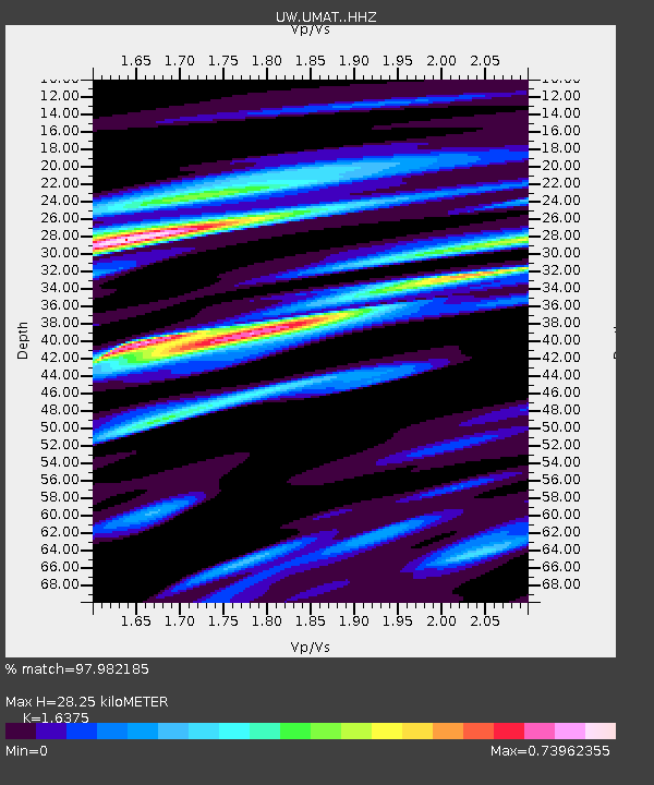
| Estimated Moho Depth: |
28.25 km |
| Estimated Crust Vp/Vs: |
1.64 |
| Assumed Crust Vp: |
6.571 km/s |
| Estimated Crust Vs: |
4.013 km/s |
| Estimated Crust Poisson's Ratio: |
0.20 |
|
| Radial Match: |
97.982185 % |
| Radial Bump: |
278 |
| Transverse Match: |
93.51662 % |
| Transverse Bump: |
400 |
| SOD ConfigId: |
7422571 |
| Insert Time: |
2019-04-22 08:09:08.213 +0000 |
| GWidth: |
2.5 |
| Max Bumps: |
400 |
| Tol: |
0.001 |
|
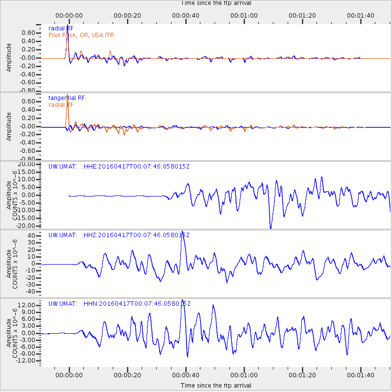
Signal To Noise
| Channel | StoN | STA | LTA |
| UW:UMAT: :HHZ:20160417T00:07:46.058015Z | 12.770646 | 1.8254797E-6 | 1.429434E-7 |
| UW:UMAT: :HHN:20160417T00:07:46.058015Z | 3.806704 | 5.9837777E-7 | 1.5719053E-7 |
| UW:UMAT: :HHE:20160417T00:07:46.058015Z | 6.1357474 | 8.587079E-7 | 1.3995164E-7 |
| Arrivals |
| Ps | 2.9 SECOND |
| PpPs | 11 SECOND |
| PsPs/PpSs | 14 SECOND |


