You are here: Home > Network List > XD14 - Illuminating the architecture of the greater Mount St. Helens magmatic systems f Stations List
> Station MG05 "Mount St Helens, WA" > Earthquake Result Viewer
MG05 "Mount St Helens, WA" - Earthquake Result Viewer
| Earthquake location: |
Near Coast Of Ecuador |
| Earthquake latitude/longitude: |
0.4/-79.9 |
| Earthquake time(UTC): |
2016/04/16 (107) 23:58:37 GMT |
| Earthquake Depth: |
19 km |
| Earthquake Magnitude: |
7.8 MWW, 7.4 MI |
| Earthquake Catalog/Contributor: |
NEIC PDE/NEIC COMCAT |
|
| Network: |
XD Illuminating the architecture of the greater Mount St. Helens magmatic systems f |
| Station: |
MG05 "Mount St Helens, WA" |
| Lat/Lon: |
46.31 N/122.34 W |
| Elevation: |
1283 m |
|
| Distance: |
58.9 deg |
| Az: |
326.911 deg |
| Baz: |
128.047 deg |
| Ray Param: |
0.06252218 |
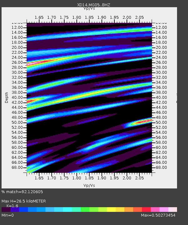
| Estimated Moho Depth: |
26.5 km |
| Estimated Crust Vp/Vs: |
1.60 |
| Assumed Crust Vp: |
6.566 km/s |
| Estimated Crust Vs: |
4.104 km/s |
| Estimated Crust Poisson's Ratio: |
0.18 |
|
| Radial Match: |
92.120605 % |
| Radial Bump: |
400 |
| Transverse Match: |
80.58763 % |
| Transverse Bump: |
400 |
| SOD ConfigId: |
7422571 |
| Insert Time: |
2019-04-22 08:09:46.352 +0000 |
| GWidth: |
2.5 |
| Max Bumps: |
400 |
| Tol: |
0.001 |
|

Signal To Noise
| Channel | StoN | STA | LTA |
| XD:MG05: :BHZ:20160417T00:08:03.405Z | 11.866918 | 1.6326311E-6 | 1.3757837E-7 |
| XD:MG05: :BHN:20160417T00:08:03.405Z | 4.714828 | 5.4045506E-7 | 1.1462879E-7 |
| XD:MG05: :BHE:20160417T00:08:03.405Z | 4.3523936 | 6.0504334E-7 | 1.3901392E-7 |
| Arrivals |
| Ps | 2.6 SECOND |
| PpPs | 9.9 SECOND |
| PsPs/PpSs | 12 SECOND |


