You are here: Home > Network List > XD14 - Illuminating the architecture of the greater Mount St. Helens magmatic systems f Stations List
> Station MG07 "Mount St Helens, WA" > Earthquake Result Viewer
MG07 "Mount St Helens, WA" - Earthquake Result Viewer
| Earthquake location: |
Near Coast Of Ecuador |
| Earthquake latitude/longitude: |
0.4/-79.9 |
| Earthquake time(UTC): |
2016/04/16 (107) 23:58:37 GMT |
| Earthquake Depth: |
19 km |
| Earthquake Magnitude: |
7.8 MWW, 7.4 MI |
| Earthquake Catalog/Contributor: |
NEIC PDE/NEIC COMCAT |
|
| Network: |
XD Illuminating the architecture of the greater Mount St. Helens magmatic systems f |
| Station: |
MG07 "Mount St Helens, WA" |
| Lat/Lon: |
46.35 N/122.03 W |
| Elevation: |
1457 m |
|
| Distance: |
58.8 deg |
| Az: |
327.11 deg |
| Baz: |
128.374 deg |
| Ray Param: |
0.062613554 |
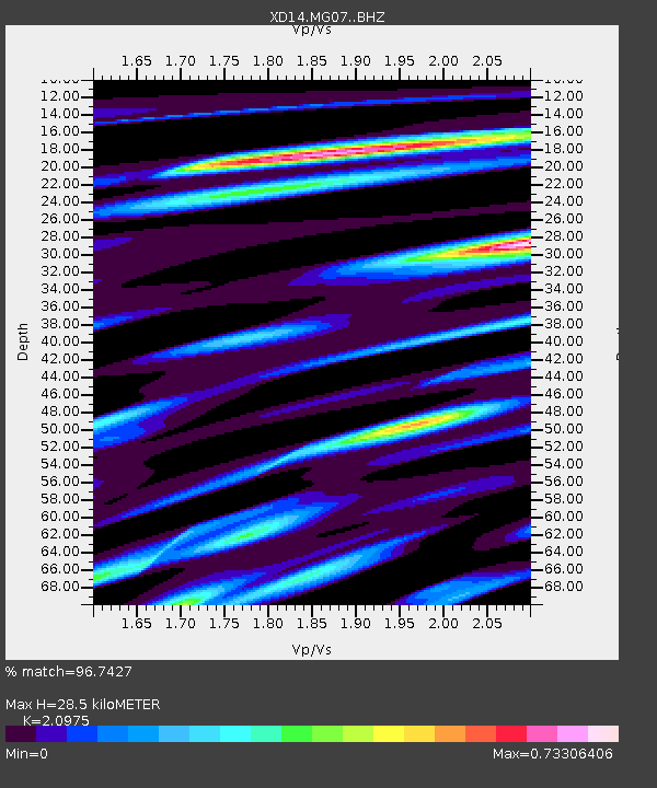
| Estimated Moho Depth: |
28.5 km |
| Estimated Crust Vp/Vs: |
2.10 |
| Assumed Crust Vp: |
6.566 km/s |
| Estimated Crust Vs: |
3.13 km/s |
| Estimated Crust Poisson's Ratio: |
0.35 |
|
| Radial Match: |
96.7427 % |
| Radial Bump: |
335 |
| Transverse Match: |
84.089745 % |
| Transverse Bump: |
400 |
| SOD ConfigId: |
7422571 |
| Insert Time: |
2019-04-22 08:09:47.223 +0000 |
| GWidth: |
2.5 |
| Max Bumps: |
400 |
| Tol: |
0.001 |
|

Signal To Noise
| Channel | StoN | STA | LTA |
| XD:MG07: :BHZ:20160417T00:08:02.444978Z | 8.755773 | 1.6898566E-6 | 1.9299914E-7 |
| XD:MG07: :BHN:20160417T00:08:02.444978Z | 4.326065 | 6.282928E-7 | 1.4523425E-7 |
| XD:MG07: :BHE:20160417T00:08:02.444978Z | 4.7922697 | 6.6315505E-7 | 1.3838014E-7 |
| Arrivals |
| Ps | 5.0 SECOND |
| PpPs | 13 SECOND |
| PsPs/PpSs | 18 SECOND |


