You are here: Home > Network List > XD14 - Illuminating the architecture of the greater Mount St. Helens magmatic systems f Stations List
> Station MP04 "Mount St Helens, WA" > Earthquake Result Viewer
MP04 "Mount St Helens, WA" - Earthquake Result Viewer
| Earthquake location: |
Near Coast Of Ecuador |
| Earthquake latitude/longitude: |
0.4/-79.9 |
| Earthquake time(UTC): |
2016/04/16 (107) 23:58:37 GMT |
| Earthquake Depth: |
19 km |
| Earthquake Magnitude: |
7.8 MWW, 7.4 MI |
| Earthquake Catalog/Contributor: |
NEIC PDE/NEIC COMCAT |
|
| Network: |
XD Illuminating the architecture of the greater Mount St. Helens magmatic systems f |
| Station: |
MP04 "Mount St Helens, WA" |
| Lat/Lon: |
45.81 N/122.38 W |
| Elevation: |
497 m |
|
| Distance: |
58.6 deg |
| Az: |
326.436 deg |
| Baz: |
127.772 deg |
| Ray Param: |
0.06270576 |
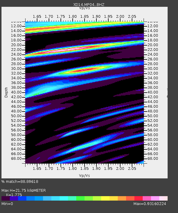
| Estimated Moho Depth: |
21.75 km |
| Estimated Crust Vp/Vs: |
1.77 |
| Assumed Crust Vp: |
6.566 km/s |
| Estimated Crust Vs: |
3.699 km/s |
| Estimated Crust Poisson's Ratio: |
0.27 |
|
| Radial Match: |
88.89618 % |
| Radial Bump: |
400 |
| Transverse Match: |
75.48991 % |
| Transverse Bump: |
400 |
| SOD ConfigId: |
7422571 |
| Insert Time: |
2019-04-22 08:10:18.172 +0000 |
| GWidth: |
2.5 |
| Max Bumps: |
400 |
| Tol: |
0.001 |
|

Signal To Noise
| Channel | StoN | STA | LTA |
| XD:MP04: :BHZ:20160417T00:08:01.464998Z | 10.837439 | 1.9260149E-6 | 1.7771865E-7 |
| XD:MP04: :BHN:20160417T00:08:01.464998Z | 2.229375 | 5.049215E-7 | 2.264857E-7 |
| XD:MP04: :BHE:20160417T00:08:01.464998Z | 1.7143146 | 5.605913E-7 | 3.2700606E-7 |
| Arrivals |
| Ps | 2.7 SECOND |
| PpPs | 8.7 SECOND |
| PsPs/PpSs | 11 SECOND |


