You are here: Home > Network List > YN10 - San Jacinto Fault Zone Stations List
> Station JFS4 JFS4 > Earthquake Result Viewer
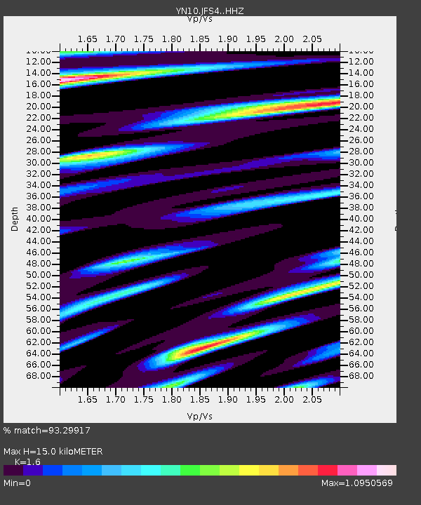
JFS4 JFS4 - Earthquake Result Viewer
| Earthquake location: |
Near Coast Of Ecuador |
| Earthquake latitude/longitude: |
0.4/-79.9 |
| Earthquake time(UTC): |
2016/04/16 (107) 23:58:37 GMT |
| Earthquake Depth: |
19 km |
| Earthquake Magnitude: |
7.8 MWW, 7.4 MI |
| Earthquake Catalog/Contributor: |
NEIC PDE/NEIC COMCAT |
|
| Network: |
YN San Jacinto Fault Zone |
| Station: |
JFS4 JFS4 |
| Lat/Lon: |
33.42 N/116.40 W |
| Elevation: |
645 m |
|
| Distance: |
47.5 deg |
| Az: |
317.578 deg |
| Baz: |
126.235 deg |
| Ray Param: |
0.069950804 |
| Estimated Moho Depth: |
15.0 km |
| Estimated Crust Vp/Vs: |
1.60 |
| Assumed Crust Vp: |
6.264 km/s |
| Estimated Crust Vs: |
3.915 km/s |
| Estimated Crust Poisson's Ratio: |
0.18 |
|
| Radial Match: |
93.29917 % |
| Radial Bump: |
400 |
| Transverse Match: |
88.74301 % |
| Transverse Bump: |
400 |
| SOD ConfigId: |
7422571 |
| Insert Time: |
2019-04-22 08:11:27.686 +0000 |
| GWidth: |
2.5 |
| Max Bumps: |
400 |
| Tol: |
0.001 |
|

Signal To Noise
| Channel | StoN | STA | LTA |
| YN:JFS4: :HHZ:20160417T00:06:39.378999Z | 3.124312 | 1.1493745E-6 | 3.6788083E-7 |
| YN:JFS4: :HHN:20160417T00:06:39.378999Z | 3.0937002 | 7.365421E-7 | 2.3807804E-7 |
| YN:JFS4: :HHE:20160417T00:06:39.378999Z | 0.48826844 | 2.765997E-7 | 5.6649105E-7 |
| Arrivals |
| Ps | 1.5 SECOND |
| PpPs | 5.8 SECOND |
| PsPs/PpSs | 7.4 SECOND |


