You are here: Home > Network List > GS - US Geological Survey Networks Stations List
> Station DEC07 Decatur Surface Seismic Site, Decatur, IL, USA > Earthquake Result Viewer
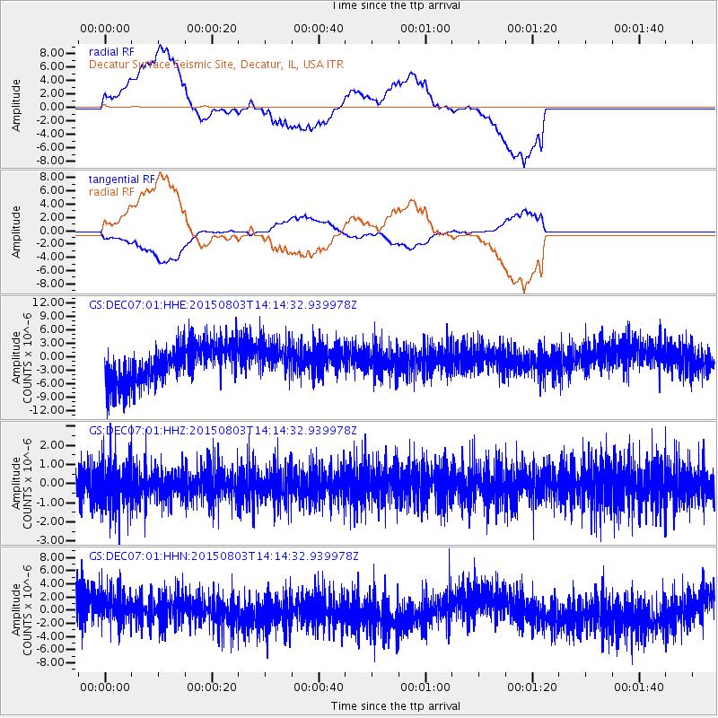
DEC07 Decatur Surface Seismic Site, Decatur, IL, USA - Earthquake Result Viewer
*The percent match for this event was below the threshold and hence no stack was calculated.
| Earthquake location: |
Tonga Islands |
| Earthquake latitude/longitude: |
-16.5/-174.3 |
| Earthquake time(UTC): |
2015/08/03 (215) 14:01:51 GMT |
| Earthquake Depth: |
162 km |
| Earthquake Magnitude: |
5.7 MWB, 5.7 MWW |
| Earthquake Catalog/Contributor: |
NEIC PDE/NEIC COMCAT |
|
| Network: |
GS US Geological Survey Networks |
| Station: |
DEC07 Decatur Surface Seismic Site, Decatur, IL, USA |
| Lat/Lon: |
39.86 N/88.90 W |
| Elevation: |
212 m |
|
| Distance: |
97.0 deg |
| Az: |
50.617 deg |
| Baz: |
254.486 deg |
| Ray Param: |
$rayparam |
*The percent match for this event was below the threshold and hence was not used in the summary stack. |
|
| Radial Match: |
51.622643 % |
| Radial Bump: |
400 |
| Transverse Match: |
48.862465 % |
| Transverse Bump: |
400 |
| SOD ConfigId: |
1085051 |
| Insert Time: |
2015-08-17 14:35:35.915 +0000 |
| GWidth: |
2.5 |
| Max Bumps: |
400 |
| Tol: |
0.001 |
|
Signal To Noise
| Channel | StoN | STA | LTA |
| GS:DEC07:01:HHZ:20150803T14:14:32.939978Z | 1.3670266 | 1.1434654E-6 | 8.3646177E-7 |
| GS:DEC07:01:HHN:20150803T14:14:32.939978Z | 0.9735078 | 3.3939539E-6 | 3.4863142E-6 |
| GS:DEC07:01:HHE:20150803T14:14:32.939978Z | 0.85009426 | 3.633893E-6 | 4.274694E-6 |
| Arrivals |
| Ps | |
| PpPs | |
| PsPs/PpSs | |


