You are here: Home > Network List > TA - USArray Transportable Network (new EarthScope stations) Stations List
> Station A21K Barrow, AK, USA > Earthquake Result Viewer
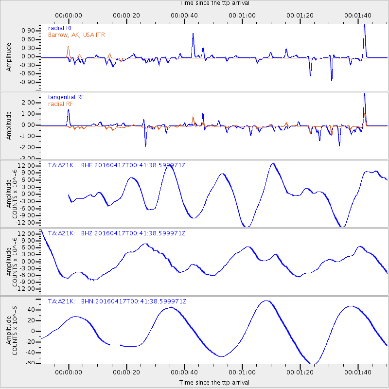
A21K Barrow, AK, USA - Earthquake Result Viewer
*The percent match for this event was below the threshold and hence no stack was calculated.
| Earthquake location: |
Near Coast Of Ecuador |
| Earthquake latitude/longitude: |
-0.3/-80.5 |
| Earthquake time(UTC): |
2016/04/17 (108) 00:29:31 GMT |
| Earthquake Depth: |
16 km |
| Earthquake Magnitude: |
5.5 MB |
| Earthquake Catalog/Contributor: |
NEIC PDE/NEIC COMCAT |
|
| Network: |
TA USArray Transportable Network (new EarthScope stations) |
| Station: |
A21K Barrow, AK, USA |
| Lat/Lon: |
71.32 N/156.62 W |
| Elevation: |
577 m |
|
| Distance: |
85.8 deg |
| Az: |
341.721 deg |
| Baz: |
103.218 deg |
| Ray Param: |
$rayparam |
*The percent match for this event was below the threshold and hence was not used in the summary stack. |
|
| Radial Match: |
61.169933 % |
| Radial Bump: |
287 |
| Transverse Match: |
68.40062 % |
| Transverse Bump: |
290 |
| SOD ConfigId: |
7422571 |
| Insert Time: |
2019-04-22 08:18:13.177 +0000 |
| GWidth: |
2.5 |
| Max Bumps: |
400 |
| Tol: |
0.001 |
|
Signal To Noise
| Channel | StoN | STA | LTA |
| TA:A21K: :BHZ:20160417T00:41:38.599971Z | 0.9174028 | 7.534135E-6 | 8.212462E-6 |
| TA:A21K: :BHN:20160417T00:41:38.599971Z | 5.3372507 | 3.2051936E-5 | 6.005327E-6 |
| TA:A21K: :BHE:20160417T00:41:38.599971Z | 2.289433 | 7.52771E-6 | 3.2880237E-6 |
| Arrivals |
| Ps | |
| PpPs | |
| PsPs/PpSs | |


