You are here: Home > Network List > TA - USArray Transportable Network (new EarthScope stations) Stations List
> Station M22K Willow, AK, USA > Earthquake Result Viewer
M22K Willow, AK, USA - Earthquake Result Viewer
| Earthquake location: |
Near Coast Of Ecuador |
| Earthquake latitude/longitude: |
-0.3/-80.5 |
| Earthquake time(UTC): |
2016/04/17 (108) 00:29:31 GMT |
| Earthquake Depth: |
16 km |
| Earthquake Magnitude: |
5.5 MB |
| Earthquake Catalog/Contributor: |
NEIC PDE/NEIC COMCAT |
|
| Network: |
TA USArray Transportable Network (new EarthScope stations) |
| Station: |
M22K Willow, AK, USA |
| Lat/Lon: |
61.75 N/150.12 W |
| Elevation: |
57 m |
|
| Distance: |
80.7 deg |
| Az: |
333.129 deg |
| Baz: |
108.183 deg |
| Ray Param: |
0.048079096 |
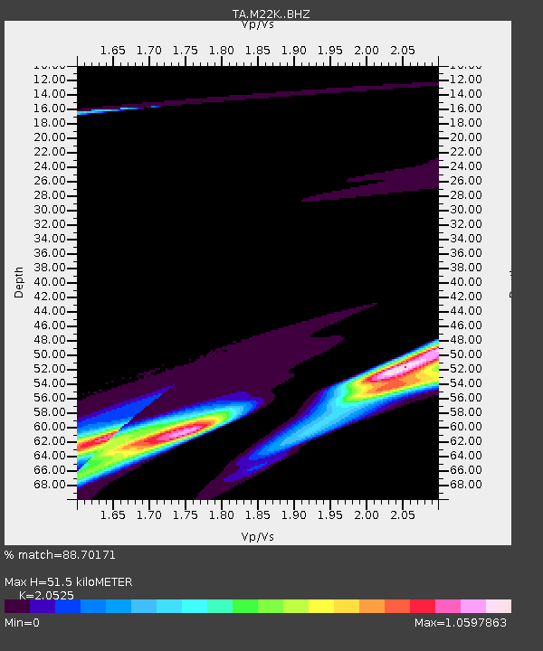
| Estimated Moho Depth: |
51.5 km |
| Estimated Crust Vp/Vs: |
2.05 |
| Assumed Crust Vp: |
6.302 km/s |
| Estimated Crust Vs: |
3.07 km/s |
| Estimated Crust Poisson's Ratio: |
0.34 |
|
| Radial Match: |
88.70171 % |
| Radial Bump: |
400 |
| Transverse Match: |
52.91831 % |
| Transverse Bump: |
400 |
| SOD ConfigId: |
7422571 |
| Insert Time: |
2019-04-22 08:18:27.959 +0000 |
| GWidth: |
2.5 |
| Max Bumps: |
400 |
| Tol: |
0.001 |
|

Signal To Noise
| Channel | StoN | STA | LTA |
| TA:M22K: :BHZ:20160417T00:41:12.325007Z | 3.9448307 | 2.0943156E-5 | 5.309013E-6 |
| TA:M22K: :BHN:20160417T00:41:12.325007Z | 1.1707115 | 3.7589412E-5 | 3.2108175E-5 |
| TA:M22K: :BHE:20160417T00:41:12.325007Z | 2.343889 | 1.9137051E-5 | 8.164658E-6 |
| Arrivals |
| Ps | 8.8 SECOND |
| PpPs | 24 SECOND |
| PsPs/PpSs | 33 SECOND |


