You are here: Home > Network List > TA - USArray Transportable Network (new EarthScope stations) Stations List
> Station O03E Paynes Creek, CA, USA > Earthquake Result Viewer
O03E Paynes Creek, CA, USA - Earthquake Result Viewer
| Earthquake location: |
Near Coast Of Ecuador |
| Earthquake latitude/longitude: |
-0.3/-80.5 |
| Earthquake time(UTC): |
2016/04/17 (108) 00:29:31 GMT |
| Earthquake Depth: |
16 km |
| Earthquake Magnitude: |
5.5 MB |
| Earthquake Catalog/Contributor: |
NEIC PDE/NEIC COMCAT |
|
| Network: |
TA USArray Transportable Network (new EarthScope stations) |
| Station: |
O03E Paynes Creek, CA, USA |
| Lat/Lon: |
40.29 N/121.80 W |
| Elevation: |
967 m |
|
| Distance: |
55.2 deg |
| Az: |
322.009 deg |
| Baz: |
126.413 deg |
| Ray Param: |
0.06496522 |
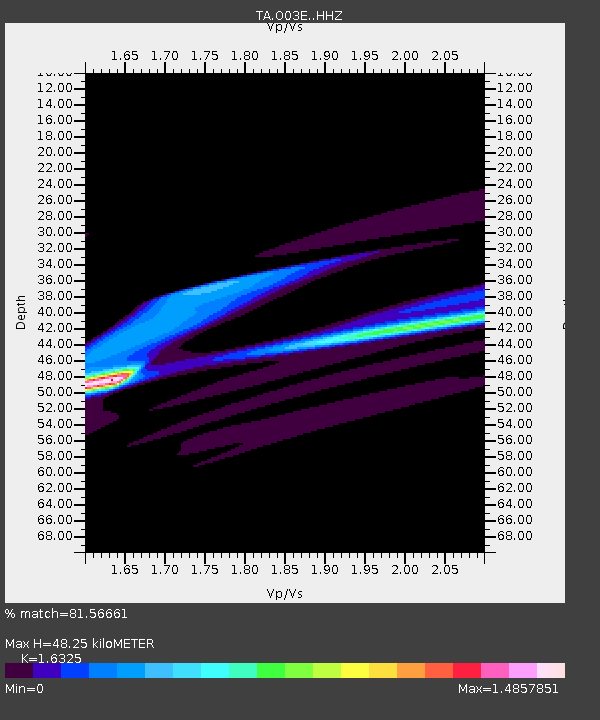
| Estimated Moho Depth: |
48.25 km |
| Estimated Crust Vp/Vs: |
1.63 |
| Assumed Crust Vp: |
6.566 km/s |
| Estimated Crust Vs: |
4.022 km/s |
| Estimated Crust Poisson's Ratio: |
0.20 |
|
| Radial Match: |
81.56661 % |
| Radial Bump: |
397 |
| Transverse Match: |
42.060368 % |
| Transverse Bump: |
169 |
| SOD ConfigId: |
7422571 |
| Insert Time: |
2019-04-22 08:18:33.334 +0000 |
| GWidth: |
2.5 |
| Max Bumps: |
400 |
| Tol: |
0.001 |
|
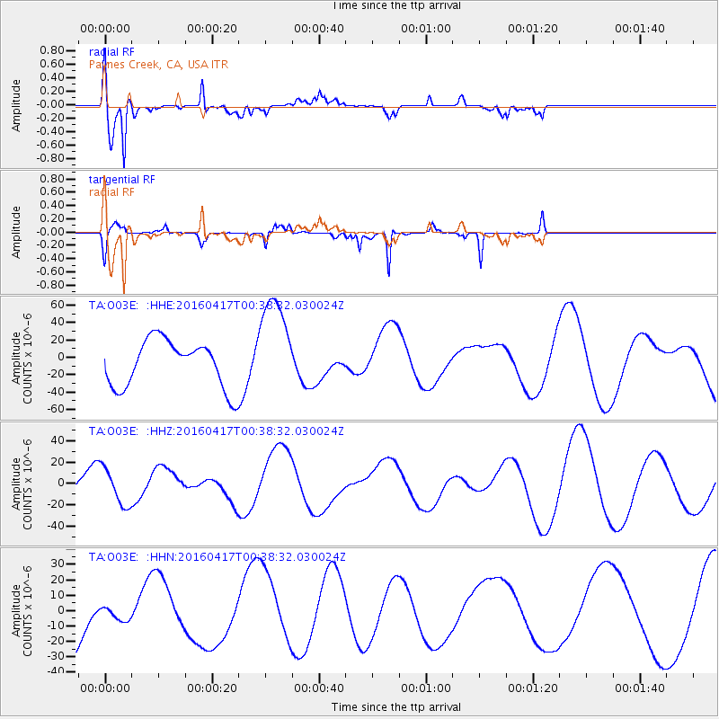
Signal To Noise
| Channel | StoN | STA | LTA |
| TA:O03E: :HHZ:20160417T00:38:32.030024Z | 0.6551516 | 1.7139428E-5 | 2.616101E-5 |
| TA:O03E: :HHN:20160417T00:38:32.030024Z | 0.15098569 | 5.190211E-6 | 3.437552E-5 |
| TA:O03E: :HHE:20160417T00:38:32.030024Z | 2.1947308 | 5.9011632E-5 | 2.688787E-5 |
| Arrivals |
| Ps | 4.9 SECOND |
| PpPs | 18 SECOND |
| PsPs/PpSs | 23 SECOND |


