You are here: Home > Network List > CI - Caltech Regional Seismic Network Stations List
> Station MPM Manuel Prospect Mine, California, USA > Earthquake Result Viewer
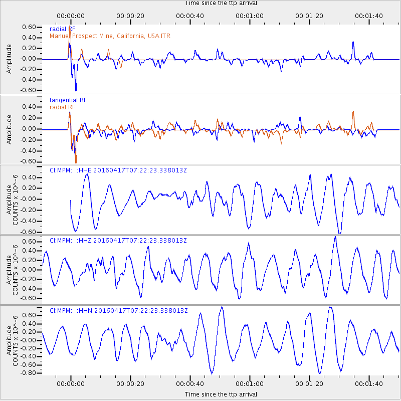
MPM Manuel Prospect Mine, California, USA - Earthquake Result Viewer
*The percent match for this event was below the threshold and hence no stack was calculated.
| Earthquake location: |
Near Coast Of Ecuador |
| Earthquake latitude/longitude: |
-0.4/-80.3 |
| Earthquake time(UTC): |
2016/04/17 (108) 07:13:59 GMT |
| Earthquake Depth: |
10 km |
| Earthquake Magnitude: |
5.6 MB |
| Earthquake Catalog/Contributor: |
NEIC PDE/NEIC ALERT |
|
| Network: |
CI Caltech Regional Seismic Network |
| Station: |
MPM Manuel Prospect Mine, California, USA |
| Lat/Lon: |
36.06 N/117.49 W |
| Elevation: |
185 m |
|
| Distance: |
50.2 deg |
| Az: |
320.325 deg |
| Baz: |
128.012 deg |
| Ray Param: |
$rayparam |
*The percent match for this event was below the threshold and hence was not used in the summary stack. |
|
| Radial Match: |
67.768845 % |
| Radial Bump: |
400 |
| Transverse Match: |
64.36151 % |
| Transverse Bump: |
400 |
| SOD ConfigId: |
7422571 |
| Insert Time: |
2019-04-22 08:23:03.349 +0000 |
| GWidth: |
2.5 |
| Max Bumps: |
400 |
| Tol: |
0.001 |
|
Signal To Noise
| Channel | StoN | STA | LTA |
| CI:MPM: :HHZ:20160417T07:22:23.338013Z | 0.5979648 | 1.7106338E-7 | 2.8607596E-7 |
| CI:MPM: :HHN:20160417T07:22:23.338013Z | 1.5754902 | 2.6579943E-7 | 1.6870904E-7 |
| CI:MPM: :HHE:20160417T07:22:23.338013Z | 0.70502317 | 1.8207525E-7 | 2.582543E-7 |
| Arrivals |
| Ps | |
| PpPs | |
| PsPs/PpSs | |


