You are here: Home > Network List > US - United States National Seismic Network Stations List
> Station NEW Newport, Washington, USA > Earthquake Result Viewer
NEW Newport, Washington, USA - Earthquake Result Viewer
| Earthquake location: |
Colombia |
| Earthquake latitude/longitude: |
5.1/-75.7 |
| Earthquake time(UTC): |
1995/08/19 (231) 21:43:32 GMT |
| Earthquake Depth: |
125 km |
| Earthquake Magnitude: |
6.1 MB, 6.6 UNKNOWN, 6.5 MW |
| Earthquake Catalog/Contributor: |
WHDF/NEIC |
|
| Network: |
US United States National Seismic Network |
| Station: |
NEW Newport, Washington, USA |
| Lat/Lon: |
48.26 N/117.12 W |
| Elevation: |
760 m |
|
| Distance: |
55.6 deg |
| Az: |
327.606 deg |
| Baz: |
127.0 deg |
| Ray Param: |
0.064282075 |
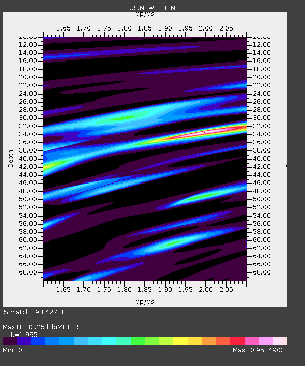
| Estimated Moho Depth: |
33.25 km |
| Estimated Crust Vp/Vs: |
2.00 |
| Assumed Crust Vp: |
6.571 km/s |
| Estimated Crust Vs: |
3.294 km/s |
| Estimated Crust Poisson's Ratio: |
0.33 |
|
| Radial Match: |
93.42718 % |
| Radial Bump: |
400 |
| Transverse Match: |
80.68689 % |
| Transverse Bump: |
400 |
| SOD ConfigId: |
110177 |
| Insert Time: |
2010-03-05 01:42:55.705 +0000 |
| GWidth: |
2.5 |
| Max Bumps: |
400 |
| Tol: |
0.001 |
|

Signal To Noise
| Channel | StoN | STA | LTA |
| US:NEW: :BHN:19950819T21:52:24.600012Z | 9.140893 | 1.0828398E-6 | 1.1846105E-7 |
| US:NEW: :BHE:19950819T21:52:24.600012Z | 9.421889 | 1.534167E-6 | 1.6283008E-7 |
| US:NEW: :BHZ:19950819T21:52:24.600012Z | 25.374062 | 3.7198147E-6 | 1.465991E-7 |
| Arrivals |
| Ps | 5.3 SECOND |
| PpPs | 14 SECOND |
| PsPs/PpSs | 20 SECOND |


