You are here: Home > Network List > US - United States National Seismic Network Stations List
> Station NEW Newport, Washington, USA > Earthquake Result Viewer
NEW Newport, Washington, USA - Earthquake Result Viewer
| Earthquake location: |
Near Coast Of Ecuador |
| Earthquake latitude/longitude: |
-0.6/-80.4 |
| Earthquake time(UTC): |
1998/08/04 (216) 18:59:20 GMT |
| Earthquake Depth: |
33 km |
| Earthquake Magnitude: |
6.2 MB, 7.1 MS, 7.1 UNKNOWN, 7.0 ME |
| Earthquake Catalog/Contributor: |
WHDF/NEIC |
|
| Network: |
US United States National Seismic Network |
| Station: |
NEW Newport, Washington, USA |
| Lat/Lon: |
48.26 N/117.12 W |
| Elevation: |
760 m |
|
| Distance: |
58.1 deg |
| Az: |
331.935 deg |
| Baz: |
135.246 deg |
| Ray Param: |
0.062982485 |
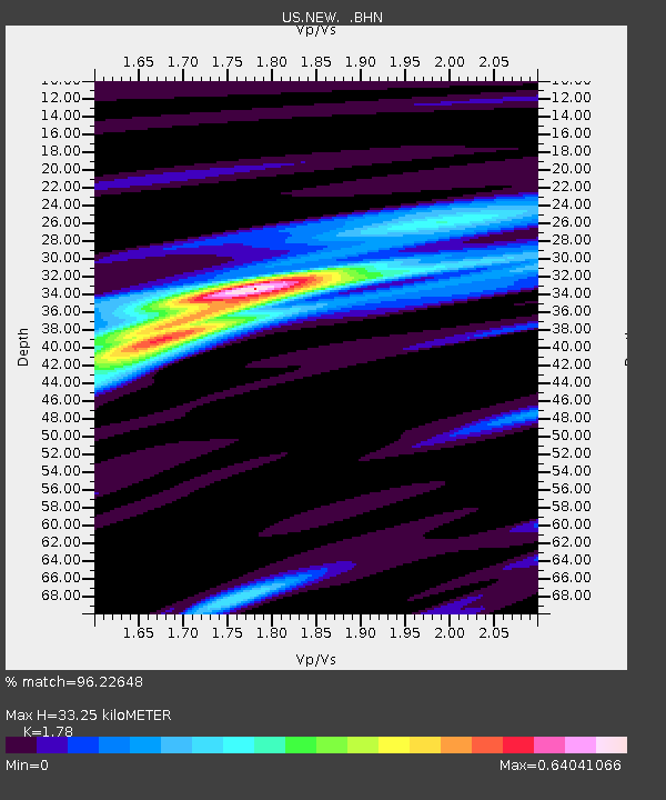
| Estimated Moho Depth: |
33.25 km |
| Estimated Crust Vp/Vs: |
1.78 |
| Assumed Crust Vp: |
6.571 km/s |
| Estimated Crust Vs: |
3.691 km/s |
| Estimated Crust Poisson's Ratio: |
0.27 |
|
| Radial Match: |
96.22648 % |
| Radial Bump: |
400 |
| Transverse Match: |
90.94933 % |
| Transverse Bump: |
400 |
| SOD ConfigId: |
110177 |
| Insert Time: |
2010-03-05 01:43:01.741 +0000 |
| GWidth: |
2.5 |
| Max Bumps: |
400 |
| Tol: |
0.001 |
|

Signal To Noise
| Channel | StoN | STA | LTA |
| US:NEW: :BHN:19980804T19:08:39.792993Z | 1.3594629 | 9.439343E-8 | 6.943436E-8 |
| US:NEW: :BHE:19980804T19:08:39.792993Z | 1.2601804 | 9.123322E-8 | 7.239696E-8 |
| US:NEW: :BHZ:19980804T19:08:39.792993Z | 2.0117712 | 2.483094E-7 | 1.2342824E-7 |
| Arrivals |
| Ps | 4.2 SECOND |
| PpPs | 13 SECOND |
| PsPs/PpSs | 18 SECOND |


