You are here: Home > Network List > LD - Lamont-Doherty Cooperative Seismographic Network Stations List
> Station MVL Millersville University, PA > Earthquake Result Viewer
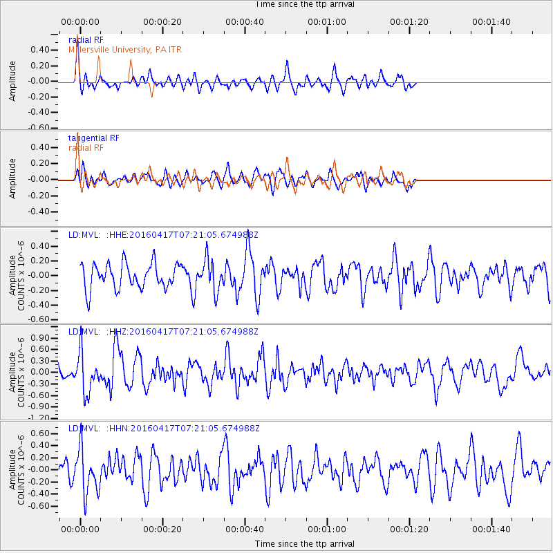
MVL Millersville University, PA - Earthquake Result Viewer
*The percent match for this event was below the threshold and hence no stack was calculated.
| Earthquake location: |
Near Coast Of Ecuador |
| Earthquake latitude/longitude: |
-0.4/-80.3 |
| Earthquake time(UTC): |
2016/04/17 (108) 07:13:59 GMT |
| Earthquake Depth: |
10 km |
| Earthquake Magnitude: |
5.6 MB |
| Earthquake Catalog/Contributor: |
NEIC PDE/NEIC ALERT |
|
| Network: |
LD Lamont-Doherty Cooperative Seismographic Network |
| Station: |
MVL Millersville University, PA |
| Lat/Lon: |
40.00 N/76.35 W |
| Elevation: |
91 m |
|
| Distance: |
40.4 deg |
| Az: |
4.643 deg |
| Baz: |
186.048 deg |
| Ray Param: |
$rayparam |
*The percent match for this event was below the threshold and hence was not used in the summary stack. |
|
| Radial Match: |
62.63441 % |
| Radial Bump: |
400 |
| Transverse Match: |
64.73126 % |
| Transverse Bump: |
400 |
| SOD ConfigId: |
7422571 |
| Insert Time: |
2019-04-22 08:25:20.455 +0000 |
| GWidth: |
2.5 |
| Max Bumps: |
400 |
| Tol: |
0.001 |
|
Signal To Noise
| Channel | StoN | STA | LTA |
| LD:MVL: :HHZ:20160417T07:21:05.674988Z | 3.2181838 | 5.3318087E-7 | 1.6567758E-7 |
| LD:MVL: :HHN:20160417T07:21:05.674988Z | 2.3547997 | 3.8282047E-7 | 1.6257029E-7 |
| LD:MVL: :HHE:20160417T07:21:05.674988Z | 1.3182034 | 2.2013533E-7 | 1.6699647E-7 |
| Arrivals |
| Ps | |
| PpPs | |
| PsPs/PpSs | |


