You are here: Home > Network List > IU - Global Seismograph Network (GSN - IRIS/USGS) Stations List
> Station RSSD Black Hills, South Dakota, USA > Earthquake Result Viewer
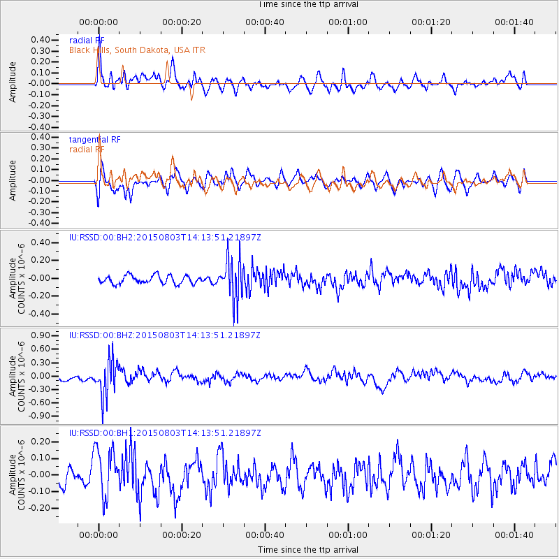
RSSD Black Hills, South Dakota, USA - Earthquake Result Viewer
*The percent match for this event was below the threshold and hence no stack was calculated.
| Earthquake location: |
Tonga Islands |
| Earthquake latitude/longitude: |
-16.5/-174.3 |
| Earthquake time(UTC): |
2015/08/03 (215) 14:01:51 GMT |
| Earthquake Depth: |
162 km |
| Earthquake Magnitude: |
5.7 MWB, 5.7 MWW |
| Earthquake Catalog/Contributor: |
NEIC PDE/NEIC COMCAT |
|
| Network: |
IU Global Seismograph Network (GSN - IRIS/USGS) |
| Station: |
RSSD Black Hills, South Dakota, USA |
| Lat/Lon: |
44.12 N/104.04 W |
| Elevation: |
2090 m |
|
| Distance: |
87.9 deg |
| Az: |
42.729 deg |
| Baz: |
244.689 deg |
| Ray Param: |
$rayparam |
*The percent match for this event was below the threshold and hence was not used in the summary stack. |
|
| Radial Match: |
59.554188 % |
| Radial Bump: |
400 |
| Transverse Match: |
56.253246 % |
| Transverse Bump: |
400 |
| SOD ConfigId: |
1085051 |
| Insert Time: |
2015-08-17 14:37:29.049 +0000 |
| GWidth: |
2.5 |
| Max Bumps: |
400 |
| Tol: |
0.001 |
|
Signal To Noise
| Channel | StoN | STA | LTA |
| IU:RSSD:00:BHZ:20150803T14:13:51.21897Z | 5.917294 | 4.1544212E-7 | 7.0208124E-8 |
| IU:RSSD:00:BH1:20150803T14:13:51.21897Z | 2.1581638 | 1.4490521E-7 | 6.714283E-8 |
| IU:RSSD:00:BH2:20150803T14:13:51.21897Z | 5.0340466 | 2.2673989E-7 | 4.504128E-8 |
| Arrivals |
| Ps | |
| PpPs | |
| PsPs/PpSs | |


