You are here: Home > Network List > US - United States National Seismic Network Stations List
> Station NEW Newport, Washington, USA > Earthquake Result Viewer
NEW Newport, Washington, USA - Earthquake Result Viewer
| Earthquake location: |
Taiwan |
| Earthquake latitude/longitude: |
23.8/121.0 |
| Earthquake time(UTC): |
1999/09/20 (263) 17:47:18 GMT |
| Earthquake Depth: |
33 km |
| Earthquake Magnitude: |
6.5 MB, 7.7 MS, 7.7 MW, 7.2 ME |
| Earthquake Catalog/Contributor: |
WHDF/NEIC |
|
| Network: |
US United States National Seismic Network |
| Station: |
NEW Newport, Washington, USA |
| Lat/Lon: |
48.26 N/117.12 W |
| Elevation: |
760 m |
|
| Distance: |
91.4 deg |
| Az: |
34.574 deg |
| Baz: |
308.918 deg |
| Ray Param: |
0.041597415 |
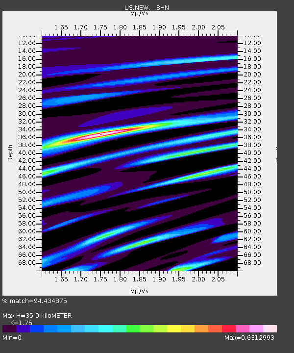
| Estimated Moho Depth: |
35.0 km |
| Estimated Crust Vp/Vs: |
1.75 |
| Assumed Crust Vp: |
6.571 km/s |
| Estimated Crust Vs: |
3.755 km/s |
| Estimated Crust Poisson's Ratio: |
0.26 |
|
| Radial Match: |
94.434875 % |
| Radial Bump: |
400 |
| Transverse Match: |
87.8058 % |
| Transverse Bump: |
400 |
| SOD ConfigId: |
110177 |
| Insert Time: |
2010-03-05 01:43:40.272 +0000 |
| GWidth: |
2.5 |
| Max Bumps: |
400 |
| Tol: |
0.001 |
|

Signal To Noise
| Channel | StoN | STA | LTA |
| US:NEW: :BHN:19990920T17:59:50.044016Z | 1.3292111 | 1.13121864E-7 | 8.510452E-8 |
| US:NEW: :BHE:19990920T17:59:50.044016Z | 0.5362387 | 7.722339E-8 | 1.4400936E-7 |
| US:NEW: :BHZ:19990920T17:59:50.044016Z | 2.13819 | 4.802968E-7 | 2.2462775E-7 |
| Arrivals |
| Ps | 4.1 SECOND |
| PpPs | 14 SECOND |
| PsPs/PpSs | 18 SECOND |


