You are here: Home > Network List > US - United States National Seismic Network Stations List
> Station NEW Newport, Washington, USA > Earthquake Result Viewer
NEW Newport, Washington, USA - Earthquake Result Viewer
| Earthquake location: |
Oaxaca, Mexico |
| Earthquake latitude/longitude: |
16.1/-96.9 |
| Earthquake time(UTC): |
1999/09/30 (273) 16:31:15 GMT |
| Earthquake Depth: |
61 km |
| Earthquake Magnitude: |
6.5 MB, 7.5 MS, 7.5 MW, 7.2 ME |
| Earthquake Catalog/Contributor: |
WHDF/NEIC |
|
| Network: |
US United States National Seismic Network |
| Station: |
NEW Newport, Washington, USA |
| Lat/Lon: |
48.26 N/117.12 W |
| Elevation: |
760 m |
|
| Distance: |
36.1 deg |
| Az: |
336.986 deg |
| Baz: |
145.768 deg |
| Ray Param: |
0.07667201 |
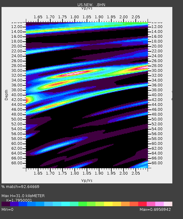
| Estimated Moho Depth: |
31.0 km |
| Estimated Crust Vp/Vs: |
1.80 |
| Assumed Crust Vp: |
6.571 km/s |
| Estimated Crust Vs: |
3.661 km/s |
| Estimated Crust Poisson's Ratio: |
0.27 |
|
| Radial Match: |
92.64669 % |
| Radial Bump: |
299 |
| Transverse Match: |
64.47379 % |
| Transverse Bump: |
400 |
| SOD ConfigId: |
110177 |
| Insert Time: |
2010-03-05 01:43:42.450 +0000 |
| GWidth: |
2.5 |
| Max Bumps: |
400 |
| Tol: |
0.001 |
|

Signal To Noise
| Channel | StoN | STA | LTA |
| US:NEW: :BHN:19990930T16:37:41.778013Z | 13.142968 | 1.9252911E-6 | 1.4648829E-7 |
| US:NEW: :BHE:19990930T16:37:41.778013Z | 11.433823 | 1.4129052E-6 | 1.2357243E-7 |
| US:NEW: :BHZ:19990930T16:37:41.778013Z | 22.175098 | 3.7030304E-6 | 1.6699049E-7 |
| Arrivals |
| Ps | 4.1 SECOND |
| PpPs | 12 SECOND |
| PsPs/PpSs | 16 SECOND |


