You are here: Home > Network List > TA - USArray Transportable Network (new EarthScope stations) Stations List
> Station A04D Lummi Island, WA, USA > Earthquake Result Viewer
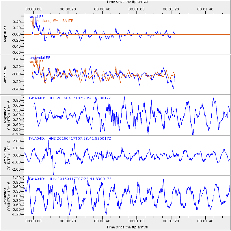
A04D Lummi Island, WA, USA - Earthquake Result Viewer
*The percent match for this event was below the threshold and hence no stack was calculated.
| Earthquake location: |
Near Coast Of Ecuador |
| Earthquake latitude/longitude: |
-0.4/-80.3 |
| Earthquake time(UTC): |
2016/04/17 (108) 07:13:59 GMT |
| Earthquake Depth: |
10 km |
| Earthquake Magnitude: |
5.6 MB |
| Earthquake Catalog/Contributor: |
NEIC PDE/NEIC ALERT |
|
| Network: |
TA USArray Transportable Network (new EarthScope stations) |
| Station: |
A04D Lummi Island, WA, USA |
| Lat/Lon: |
48.72 N/122.71 W |
| Elevation: |
13 m |
|
| Distance: |
61.1 deg |
| Az: |
329.312 deg |
| Baz: |
129.588 deg |
| Ray Param: |
$rayparam |
*The percent match for this event was below the threshold and hence was not used in the summary stack. |
|
| Radial Match: |
77.19693 % |
| Radial Bump: |
400 |
| Transverse Match: |
63.96367 % |
| Transverse Bump: |
400 |
| SOD ConfigId: |
7422571 |
| Insert Time: |
2019-04-22 08:28:45.426 +0000 |
| GWidth: |
2.5 |
| Max Bumps: |
400 |
| Tol: |
0.001 |
|
Signal To Noise
| Channel | StoN | STA | LTA |
| TA:A04D: :HHZ:20160417T07:23:41.830017Z | 2.8491664 | 7.112575E-7 | 2.4963703E-7 |
| TA:A04D: :HHN:20160417T07:23:41.830017Z | 1.1636546 | 5.8066155E-7 | 4.989982E-7 |
| TA:A04D: :HHE:20160417T07:23:41.830017Z | 1.7271001 | 4.4794567E-7 | 2.5936288E-7 |
| Arrivals |
| Ps | |
| PpPs | |
| PsPs/PpSs | |


