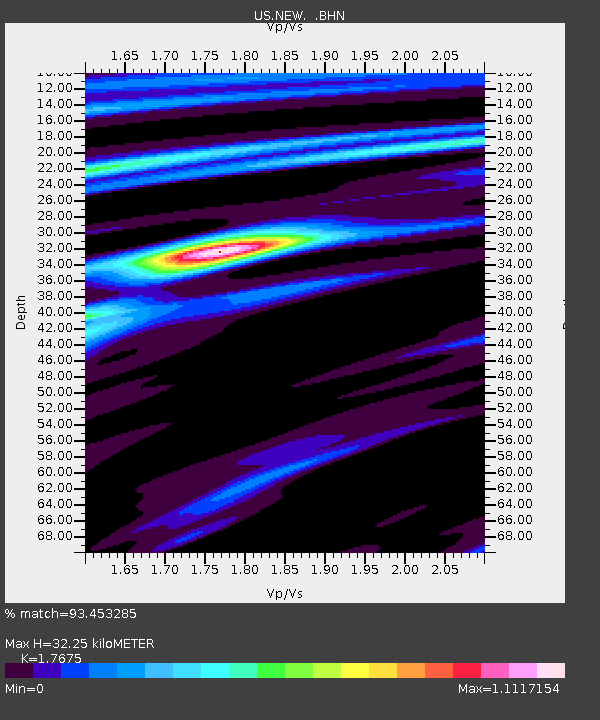
NEW Newport, Washington, USA - Earthquake Result Viewer

Earthquake location: Off Coast Of Jalisco, Mexico
Earthquake latitude/longitude: 18.8/-107.3
Earthquake time(UTC): 2009/09/24 (267) 07:16:19 GMT
Earthquake Depth: 10 km
Earthquake Magnitude: 5.8 MB, 6.2 MS, 6.3 MW, 6.3 MW
Earthquake Catalog/Contributor: WHDF/NEIC
Network: US United States National Seismic Network
Station: NEW Newport, Washington, USA
Lat/Lon: 48.26 N/117.12 W
Elevation: 760 m
Distance: 30.4 deg
Az: 347.054 deg
Baz: 161.484 deg
Ray Param: 0.07933586
Estimated Moho Depth: 32.25 km
Estimated Crust Vp/Vs: 1.77
Assumed Crust Vp: 6.571 km/s
Estimated Crust Vs: 3.718 km/s
Estimated Crust Poisson's Ratio: 0.26
Radial Match: 93.453285 %
Radial Bump: 298
Transverse Match: 79.19281 %
Transverse Bump: 400
SOD ConfigId: 2622
Insert Time: 2010-03-05 01:44:06.202 +0000
GWidth: 2.5
Max Bumps: 400
Tol: 0.001

Signal To Noise

ChannelStoNSTALTA
US:NEW: :BHN:20090924T07:22:01.523987Z7.5194491.5734178E-62.0924641E-7
US:NEW: :BHE:20090924T07:22:01.523987Z11.0920639.304829E-78.3887265E-8
US:NEW: :BHZ:20090924T07:22:01.523987Z1.46873313.324396E-72.2634448E-7
Arrivals
Ps4.1 SECOND
PpPs12 SECOND
PsPs/PpSs17 SECOND