You are here: Home > Network List > NM - Cooperative New Madrid Seismic Network Stations List
> Station SLM St. Louis, MO > Earthquake Result Viewer
SLM St. Louis, MO - Earthquake Result Viewer
| Earthquake location: |
Tonga Islands |
| Earthquake latitude/longitude: |
-16.5/-174.3 |
| Earthquake time(UTC): |
2015/08/03 (215) 14:01:51 GMT |
| Earthquake Depth: |
162 km |
| Earthquake Magnitude: |
5.7 MWB, 5.7 MWW |
| Earthquake Catalog/Contributor: |
NEIC PDE/NEIC COMCAT |
|
| Network: |
NM Cooperative New Madrid Seismic Network |
| Station: |
SLM St. Louis, MO |
| Lat/Lon: |
38.64 N/90.24 W |
| Elevation: |
186 m |
|
| Distance: |
95.6 deg |
| Az: |
51.516 deg |
| Baz: |
253.545 deg |
| Ray Param: |
0.040609617 |
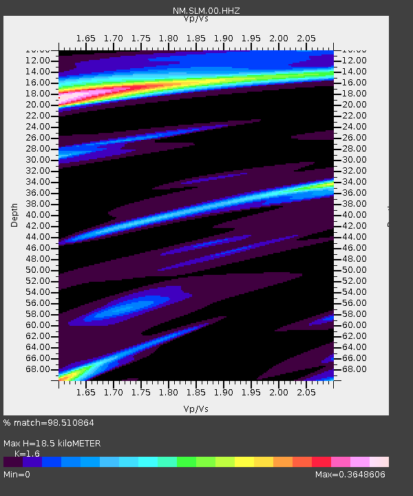
| Estimated Moho Depth: |
18.5 km |
| Estimated Crust Vp/Vs: |
1.60 |
| Assumed Crust Vp: |
6.498 km/s |
| Estimated Crust Vs: |
4.061 km/s |
| Estimated Crust Poisson's Ratio: |
0.18 |
|
| Radial Match: |
98.510864 % |
| Radial Bump: |
154 |
| Transverse Match: |
94.180725 % |
| Transverse Bump: |
382 |
| SOD ConfigId: |
1085051 |
| Insert Time: |
2015-08-17 14:40:22.217 +0000 |
| GWidth: |
2.5 |
| Max Bumps: |
400 |
| Tol: |
0.001 |
|

Signal To Noise
| Channel | StoN | STA | LTA |
| NM:SLM:00:HHZ:20150803T14:14:26.939978Z | 1.348647 | 1.2958453E-6 | 9.608484E-7 |
| NM:SLM:00:HHN:20150803T14:14:26.939978Z | 0.7906859 | 1.1620848E-7 | 1.4697174E-7 |
| NM:SLM:00:HHE:20150803T14:14:26.939978Z | 1.3458138 | 1.7595661E-6 | 1.3074366E-6 |
| Arrivals |
| Ps | 1.7 SECOND |
| PpPs | 7.2 SECOND |
| PsPs/PpSs | 9.0 SECOND |


