You are here: Home > Network List > US - United States National Seismic Network Stations List
> Station NEW Newport, Washington, USA > Earthquake Result Viewer
NEW Newport, Washington, USA - Earthquake Result Viewer
| Earthquake location: |
Vanuatu Islands |
| Earthquake latitude/longitude: |
-15.8/167.8 |
| Earthquake time(UTC): |
2006/08/07 (219) 22:18:54 GMT |
| Earthquake Depth: |
141 km |
| Earthquake Magnitude: |
6.0 MB, 6.8 MW, 6.8 MW |
| Earthquake Catalog/Contributor: |
WHDF/NEIC |
|
| Network: |
US United States National Seismic Network |
| Station: |
NEW Newport, Washington, USA |
| Lat/Lon: |
48.26 N/117.12 W |
| Elevation: |
760 m |
|
| Distance: |
92.0 deg |
| Az: |
40.246 deg |
| Baz: |
248.58 deg |
| Ray Param: |
0.04145853 |
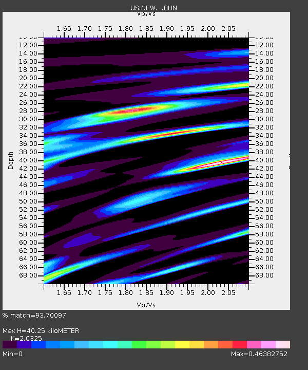
| Estimated Moho Depth: |
40.25 km |
| Estimated Crust Vp/Vs: |
2.03 |
| Assumed Crust Vp: |
6.571 km/s |
| Estimated Crust Vs: |
3.233 km/s |
| Estimated Crust Poisson's Ratio: |
0.34 |
|
| Radial Match: |
93.70097 % |
| Radial Bump: |
400 |
| Transverse Match: |
85.354225 % |
| Transverse Bump: |
400 |
| SOD ConfigId: |
2665 |
| Insert Time: |
2010-03-05 01:45:24.026 +0000 |
| GWidth: |
2.5 |
| Max Bumps: |
400 |
| Tol: |
0.001 |
|
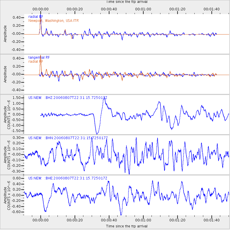
Signal To Noise
| Channel | StoN | STA | LTA |
| US:NEW: :BHN:20060807T22:31:15.725017Z | 2.124909 | 1.2768533E-7 | 6.008978E-8 |
| US:NEW: :BHE:20060807T22:31:15.725017Z | 5.6404138 | 3.3224202E-7 | 5.890384E-8 |
| US:NEW: :BHZ:20060807T22:31:15.725017Z | 16.447344 | 1.056076E-6 | 6.420951E-8 |
| Arrivals |
| Ps | 6.4 SECOND |
| PpPs | 18 SECOND |
| PsPs/PpSs | 25 SECOND |


