You are here: Home > Network List > CN - Canadian National Seismograph Network Stations List
> Station INK INUVIK, NT > Earthquake Result Viewer
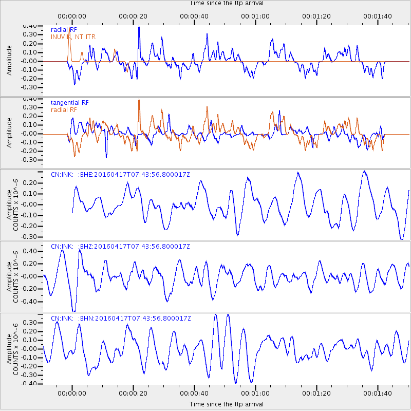
INK INUVIK, NT - Earthquake Result Viewer
*The percent match for this event was below the threshold and hence no stack was calculated.
| Earthquake location: |
Tonga Islands Region |
| Earthquake latitude/longitude: |
-23.6/-174.3 |
| Earthquake time(UTC): |
2016/04/17 (108) 07:31:03 GMT |
| Earthquake Depth: |
35 km |
| Earthquake Magnitude: |
5.8 MB |
| Earthquake Catalog/Contributor: |
NEIC PDE/NEIC COMCAT |
|
| Network: |
CN Canadian National Seismograph Network |
| Station: |
INK INUVIK, NT |
| Lat/Lon: |
68.31 N/133.53 W |
| Elevation: |
44 m |
|
| Distance: |
96.4 deg |
| Az: |
14.15 deg |
| Baz: |
217.097 deg |
| Ray Param: |
$rayparam |
*The percent match for this event was below the threshold and hence was not used in the summary stack. |
|
| Radial Match: |
78.84827 % |
| Radial Bump: |
400 |
| Transverse Match: |
52.69159 % |
| Transverse Bump: |
347 |
| SOD ConfigId: |
7422571 |
| Insert Time: |
2019-04-22 08:35:01.348 +0000 |
| GWidth: |
2.5 |
| Max Bumps: |
400 |
| Tol: |
0.001 |
|
Signal To Noise
| Channel | StoN | STA | LTA |
| CN:INK: :BHZ:20160417T07:43:56.800017Z | 2.6010208 | 3.3971588E-7 | 1.3060868E-7 |
| CN:INK: :BHN:20160417T07:43:56.800017Z | 1.1718389 | 1.4487685E-7 | 1.2363206E-7 |
| CN:INK: :BHE:20160417T07:43:56.800017Z | 1.7010365 | 1.4872815E-7 | 8.743384E-8 |
| Arrivals |
| Ps | |
| PpPs | |
| PsPs/PpSs | |


