You are here: Home > Network List > TA - USArray Transportable Network (new EarthScope stations) Stations List
> Station BGNE Belgrade, NE, USA > Earthquake Result Viewer
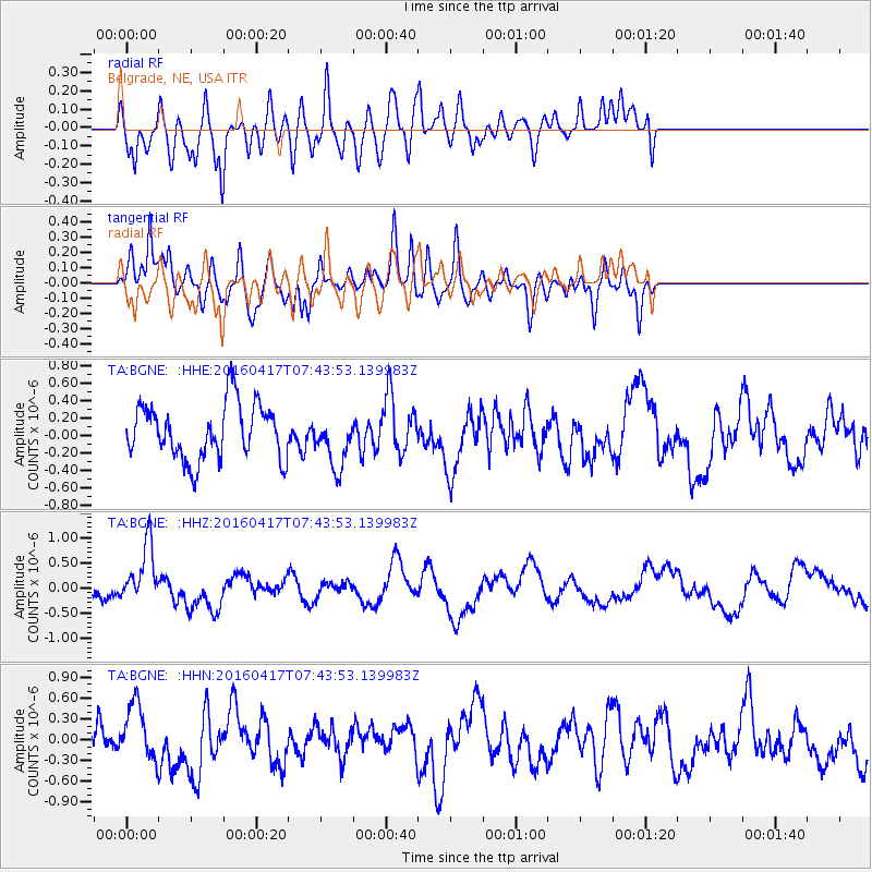
BGNE Belgrade, NE, USA - Earthquake Result Viewer
*The percent match for this event was below the threshold and hence no stack was calculated.
| Earthquake location: |
Tonga Islands Region |
| Earthquake latitude/longitude: |
-23.6/-174.3 |
| Earthquake time(UTC): |
2016/04/17 (108) 07:31:03 GMT |
| Earthquake Depth: |
35 km |
| Earthquake Magnitude: |
5.8 MB |
| Earthquake Catalog/Contributor: |
NEIC PDE/NEIC COMCAT |
|
| Network: |
TA USArray Transportable Network (new EarthScope stations) |
| Station: |
BGNE Belgrade, NE, USA |
| Lat/Lon: |
41.41 N/98.15 W |
| Elevation: |
573 m |
|
| Distance: |
95.6 deg |
| Az: |
47.215 deg |
| Baz: |
243.512 deg |
| Ray Param: |
$rayparam |
*The percent match for this event was below the threshold and hence was not used in the summary stack. |
|
| Radial Match: |
53.498363 % |
| Radial Bump: |
400 |
| Transverse Match: |
67.14868 % |
| Transverse Bump: |
400 |
| SOD ConfigId: |
7422571 |
| Insert Time: |
2019-04-22 08:37:34.904 +0000 |
| GWidth: |
2.5 |
| Max Bumps: |
400 |
| Tol: |
0.001 |
|
Signal To Noise
| Channel | StoN | STA | LTA |
| TA:BGNE: :HHZ:20160417T07:43:53.139983Z | 3.7004955 | 5.8589654E-7 | 1.583292E-7 |
| TA:BGNE: :HHN:20160417T07:43:53.139983Z | 1.1553642 | 4.0724498E-7 | 3.5248192E-7 |
| TA:BGNE: :HHE:20160417T07:43:53.139983Z | 0.94035983 | 2.9845344E-7 | 3.173822E-7 |
| Arrivals |
| Ps | |
| PpPs | |
| PsPs/PpSs | |


