You are here: Home > Network List > TA - USArray Transportable Network (new EarthScope stations) Stations List
> Station G03D McMinnville, OR, USA > Earthquake Result Viewer
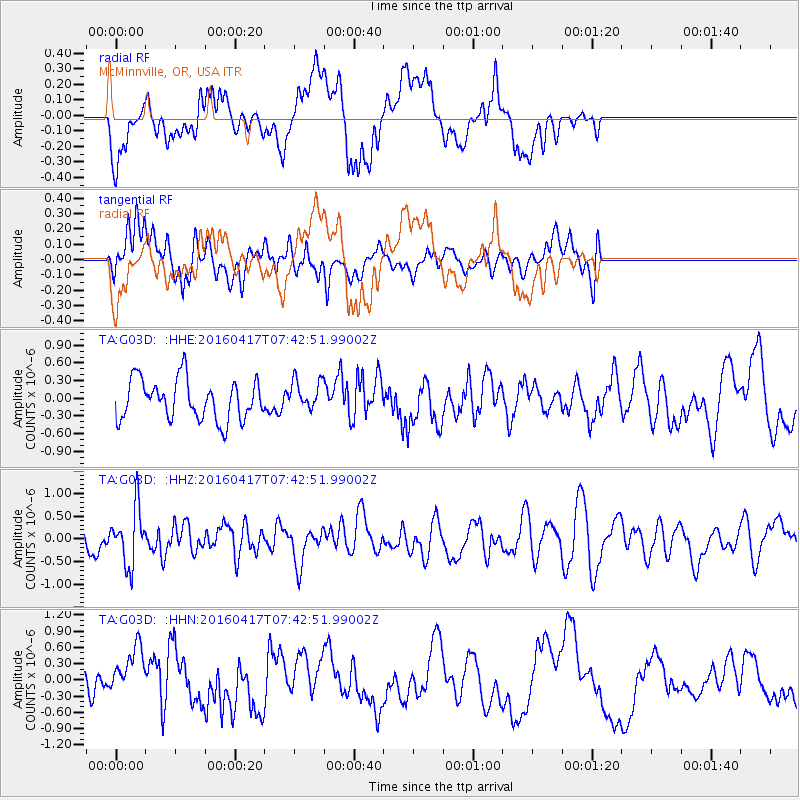
G03D McMinnville, OR, USA - Earthquake Result Viewer
*The percent match for this event was below the threshold and hence no stack was calculated.
| Earthquake location: |
Tonga Islands Region |
| Earthquake latitude/longitude: |
-23.6/-174.3 |
| Earthquake time(UTC): |
2016/04/17 (108) 07:31:03 GMT |
| Earthquake Depth: |
35 km |
| Earthquake Magnitude: |
5.8 MB |
| Earthquake Catalog/Contributor: |
NEIC PDE/NEIC COMCAT |
|
| Network: |
TA USArray Transportable Network (new EarthScope stations) |
| Station: |
G03D McMinnville, OR, USA |
| Lat/Lon: |
45.21 N/123.26 W |
| Elevation: |
222 m |
|
| Distance: |
82.8 deg |
| Az: |
33.658 deg |
| Baz: |
225.993 deg |
| Ray Param: |
$rayparam |
*The percent match for this event was below the threshold and hence was not used in the summary stack. |
|
| Radial Match: |
48.371044 % |
| Radial Bump: |
400 |
| Transverse Match: |
61.20881 % |
| Transverse Bump: |
400 |
| SOD ConfigId: |
7422571 |
| Insert Time: |
2019-04-22 08:37:39.123 +0000 |
| GWidth: |
2.5 |
| Max Bumps: |
400 |
| Tol: |
0.001 |
|
Signal To Noise
| Channel | StoN | STA | LTA |
| TA:G03D: :HHZ:20160417T07:42:51.99002Z | 2.1165245 | 6.2015545E-7 | 2.930065E-7 |
| TA:G03D: :HHN:20160417T07:42:51.99002Z | 1.392159 | 4.6883707E-7 | 3.3676977E-7 |
| TA:G03D: :HHE:20160417T07:42:51.99002Z | 0.74863225 | 2.500472E-7 | 3.340054E-7 |
| Arrivals |
| Ps | |
| PpPs | |
| PsPs/PpSs | |


