You are here: Home > Network List > TA - USArray Transportable Network (new EarthScope stations) Stations List
> Station J05D Fort Rock, OR, USA > Earthquake Result Viewer
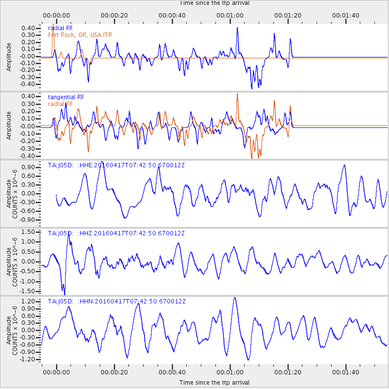
J05D Fort Rock, OR, USA - Earthquake Result Viewer
*The percent match for this event was below the threshold and hence no stack was calculated.
| Earthquake location: |
Tonga Islands Region |
| Earthquake latitude/longitude: |
-23.6/-174.3 |
| Earthquake time(UTC): |
2016/04/17 (108) 07:31:03 GMT |
| Earthquake Depth: |
35 km |
| Earthquake Magnitude: |
5.8 MB |
| Earthquake Catalog/Contributor: |
NEIC PDE/NEIC COMCAT |
|
| Network: |
TA USArray Transportable Network (new EarthScope stations) |
| Station: |
J05D Fort Rock, OR, USA |
| Lat/Lon: |
43.28 N/121.23 W |
| Elevation: |
1541 m |
|
| Distance: |
82.5 deg |
| Az: |
36.08 deg |
| Baz: |
227.715 deg |
| Ray Param: |
$rayparam |
*The percent match for this event was below the threshold and hence was not used in the summary stack. |
|
| Radial Match: |
51.461 % |
| Radial Bump: |
290 |
| Transverse Match: |
49.141094 % |
| Transverse Bump: |
400 |
| SOD ConfigId: |
7422571 |
| Insert Time: |
2019-04-22 08:37:49.685 +0000 |
| GWidth: |
2.5 |
| Max Bumps: |
400 |
| Tol: |
0.001 |
|
Signal To Noise
| Channel | StoN | STA | LTA |
| TA:J05D: :HHZ:20160417T07:42:50.670012Z | 3.515368 | 8.8801926E-7 | 2.5261062E-7 |
| TA:J05D: :HHN:20160417T07:42:50.670012Z | 1.5011904 | 6.3198945E-7 | 4.2099217E-7 |
| TA:J05D: :HHE:20160417T07:42:50.670012Z | 1.0707961 | 5.0561016E-7 | 4.721815E-7 |
| Arrivals |
| Ps | |
| PpPs | |
| PsPs/PpSs | |


